For a U.S. address, start with the FEMA Flood Map Service Center. Recenter the result on the correct building, then record the effective Flood Insurance Rate Map panel number, effective date, flood zone, Base Flood Elevation when one is shown, and any applicable Letter of Map Change. The screen identifies FEMA flood-hazard information; it does not by itself confirm a legal parcel boundary, set an insurance premium, decide a permit, or show flooding happening now.
This process is for U.S. property. FEMA calls a Flood Insurance Rate Map a FIRM, and the National Flood Hazard Layer brings together effective digital flood-hazard data where coverage is available.
Start with FEMA’s official Map Service Center
The Map Service Center is FEMA’s official public source for flood-hazard information produced for the NFIP. Enter the complete street address with city, state, and ZIP code. FEMA’s map-search instructions also allow a place name or longitude and latitude. Coordinates are useful when a rural address is not recognized, but enter longitude first and latitude second.
- Search the complete address. Do not omit the city, state, or ZIP when the street name is common.
- Open the map result. Use the address result to reach the current map, not as proof that the pin marks a surveyed boundary.
- Choose the effective product. Use Search All Products when you need the FIRM panel, Flood Insurance Study, historic material, or a map-change document.
- Save identifying details. Record the community name or number, panel number and suffix, effective date, and the date you performed the check.
Make sure the map is centered on the right building
An address search can center the map on an approximate location. Zoom out far enough to recognize the road pattern, then recenter on the building you mean to check. Compare the result with a reliable parcel or assessor map when the lot boundary matters, but do not copy a parcel outline from another system and call it part of the FEMA map.
- Confirm the street number, street name, city, state, and ZIP shown by the search.
- Check that the pin is on the correct building, not the road centerline, a neighboring structure, or a similarly named place.
- For a large lot or multiple buildings, save the coordinates or mark the specific structure you reviewed.
- If a lender, surveyor, insurer, or permit office supplied a legal description, use it to identify the structure but let that party make its own formal determination.
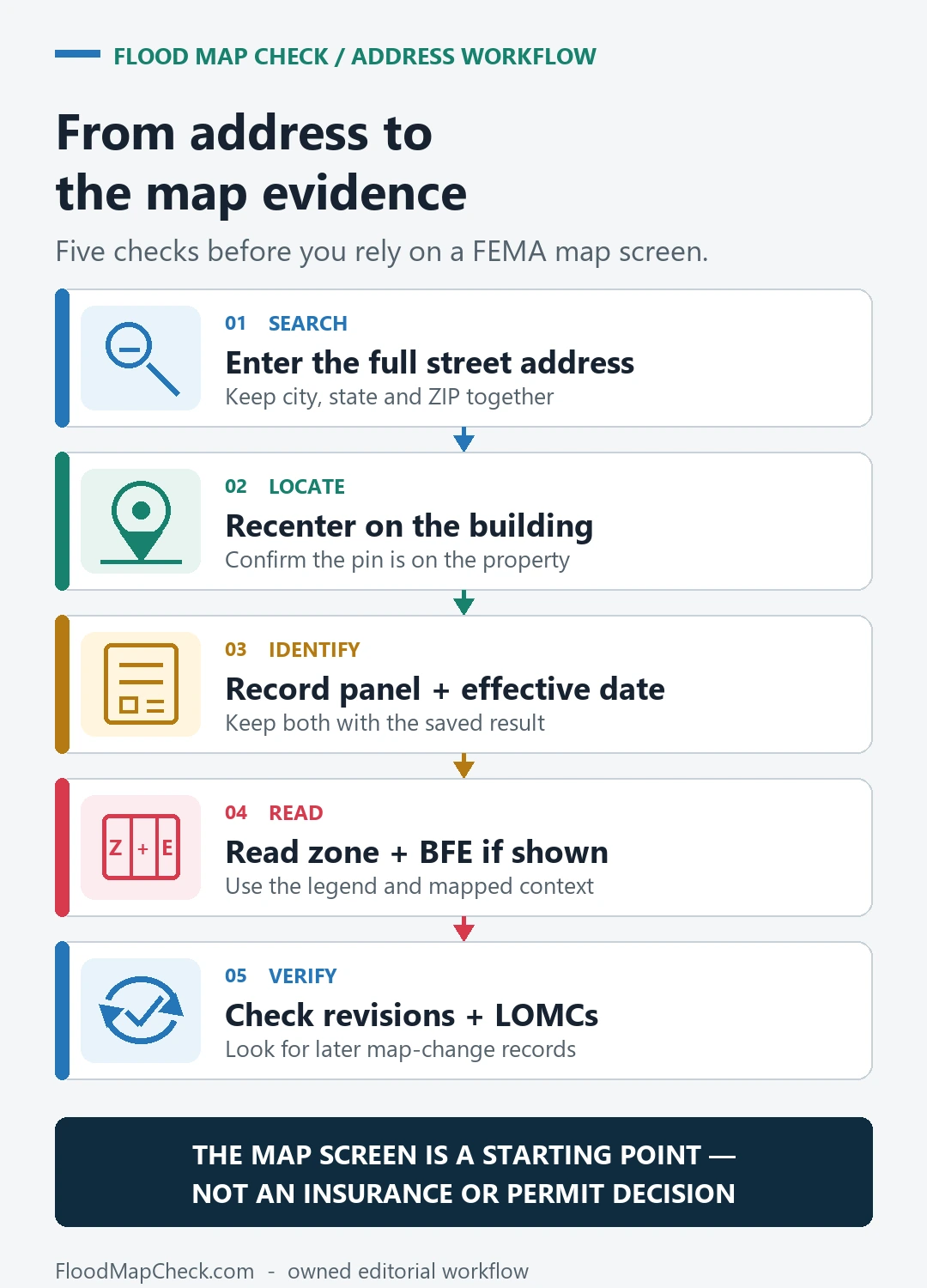
Record the effective panel, date, zone and BFE
Once the location is correct, read the effective product rather than relying on color. The panel number connects the location to a particular FIRM sheet. The effective date tells you which adopted map version you are reading. The zone describes the mapped flood-hazard classification, while a Base Flood Elevation is available only where FEMA has established and displayed one.
| Map field | What to record | What it does not prove |
|---|---|---|
| Community | Community name and six-digit community number when shown | That every incorporated area is on the same older panel |
| FIRM panel | Panel number, suffix, and map index reference | A surveyed parcel boundary |
| Effective date | The date printed for the effective FIRM product | That preliminary or pending data is already effective |
| Flood zone | The exact zone label and the map legend used | A current flood warning or an insurance premium |
| BFE | The elevation value and datum only when the map or study shows it | The finished-floor elevation of a specific building |
Do not infer a BFE from a nearby label. Approximate Zone A areas may not show one, and engineering or construction work requires the applicable map, study, datum, and professional review.
For a closer explanation of panel identifiers and map dates, use the FEMA FIRM panel guide. It helps separate the community number, panel number, suffix, index, and effective date before you attach a map to a file.
Check LOMCs and maps that are not yet effective
The current effective FIRM is not always the last document you need. FEMA may publish preliminary or pending products that show proposed changes, and FEMA can issue Letters of Map Change that amend or revise effective mapping for a structure, property, or area. A clean review records the status of each product instead of blending them into one answer.
| Product status | Use it for | Do not treat it as |
|---|---|---|
| Effective | Current adopted NFIP mapping and the starting point for official review | A guarantee that flooding cannot occur outside mapped areas |
| Preliminary | Awareness, review, appeals, and planning for a proposed map update | The effective map for policy rating or a mandatory-purchase determination |
| Pending | A map change that has completed key review steps but has not reached its effective date | Already effective merely because it is visible |
| Historic | Understanding what map applied in an earlier period | The current map |
| LOMC | An official letter that may amend or revise an effective map for the stated case | A change that automatically applies to a different parcel or survives every later map revision |
Open the case document and verify the case number, property description, determination, effective date, and current status. Some earlier Letters of Map Change are incorporated, superseded, or revalidated when a new FIRM becomes effective. The LOMA and LOMR-F lookup guide explains how to find the official determination instead of relying on a map note or an owner’s recollection.
When FEMA shows more than one map status, compare them with the preliminary versus effective flood map guide. A proposed change can matter for project planning, but it must remain labeled as proposed or pending until its effective date.
If the address search is wrong or no digital layer appears
A failed search does not mean the location has no flood risk. The address may be new, formatted differently, rural, outside the viewer’s geocoding coverage, or covered by an older nondigital product. Move from the address search to the map products rather than stopping at a blank result.
- Try the standardized mailing address, then the place name or longitude and latitude.
- Open Search All Products and search by jurisdiction, community name or number, or product ID.
- Use the FIRM index to identify the panel and check whether that panel was printed or has digital NFHL coverage.
- Ask the community map repository or local floodplain administrator which current effective product applies.
- Check current warnings and local drainage or planning information separately; they answer different questions from an effective FIRM.
The address-not-found troubleshooting guide covers spelling, unit numbers, coordinates, parcel references, and local-office fallback in more detail. Keep a note of every source and search term you tried so another reviewer can reproduce the check.
What the FEMA map does—and does not—decide
An effective FEMA map is official flood-hazard evidence for the NFIP, but several property decisions still require a separate actor and record. Keep the map result modest so it is not mistaken for a certificate, quote, permit, or emergency report.
- Insurance premium: a flood zone alone does not calculate a premium. FEMA’s Risk Rating 2.0 uses property-specific risk and building information in addition to mapping data.
- Lender decision: the lender or its determination provider decides how the mandatory-purchase requirement applies to the loan and structure.
- Permit or development review: the local floodplain, building, or planning authority applies its ordinance, adopted data, and project requirements.
- Parcel or elevation evidence: a survey, Elevation Certificate, or other professional document may be needed when a boundary or building elevation is disputed.
- Current conditions: the effective FIRM is not a live flood warning, rainfall forecast, evacuation map, or record of every past flood.
FEMA notes that flood hazards change as weather, erosion, development, studies, and mapping improve. A property outside a high-risk zone can still flood, and an unshaded or unmapped location is not a promise of safety. For insurance pricing, use an agent or insurer; for permits, use the local authority; and for a lender dispute, keep the official determination and the effective map evidence together.
Use the result for the next official check
Save one reproducible record: the full address or coordinates, a screenshot centered on the building, community and panel identifiers, effective date, zone and BFE when shown, applicable LOMC case numbers, official URLs, and the date checked. That file is useful because it shows exactly what you reviewed without pretending to make the later decision.
If you were asked for an Elevation Certificate, the recipient guide explains whether it normally goes to the local office, insurer, lender, or a complete FEMA map-change application. If a lender’s flood-zone determination appears to conflict with the record, use the Letter of Determination Review guide to keep that dispute separate from the map lookup itself.
For a local source comparison, use the Harris County flood map by address guide to separate FEMT layers, the effective FEMA FIRM, and live gauges.
Related official record checks
Use the guide that matches the exact agency, jurisdiction, tool, product, program, or record type; verify the live official source before acting.
- FEMA FIRM Index: Check Whether a Panel Is Printed, Not Printed, or Not Included
- FEMA Community Number Lookup: Match the Six-Digit CID Before Reading a FIRM
Use the guide that matches the exact agency, jurisdiction, tool, product, program, or record type; verify the live official source before acting.
- FIRM Panel Number and Suffix: Reconstruct the Full Map Number
- Base Flood Depth vs Base Flood Elevation: Read the Number With Its Zone
Use the guide that matches the exact agency, jurisdiction, tool, product, program, or record type; verify the live official source before acting.
- Flood Zone Boundary Crosses a Parcel: Which Point or Structure Matters?
- FEMA Flood Zone D: What Undetermined Risk Does and Does Not Mean
Use the guide that matches the exact agency, jurisdiction, tool, product, program, or record type; verify the live official source before acting.
Questions after the map search
Does Zone X mean the property cannot flood?
No. A zone label describes mapped flood-hazard information for the effective product; it is not a guarantee that a building will never flood. Local drainage, rainfall, coastal, dam, levee, and changing-condition risks may require other sources.
Can I use a preliminary map for an insurance decision?
Use it to understand a proposed change, but do not present it as the current effective FIRM. Preliminary and pending information is not effective for NFIP policy rating or the mandatory-purchase requirement until the applicable map becomes effective.
Last checked July 28, 2026. FEMA products and local requirements can change; reopen the official sources when a transaction, policy, permit, or map-change case depends on the result.
Find the applicable Base Flood Elevation
- How to Find a Base Flood Elevation in a FEMA FIRM and Flood Insurance Study — Find the applicable Base Flood Elevation in the FIRM and Flood Insurance Study instead of estimating it from map color.
Confirm NFIP participation and CRS status
- Is My Community in the NFIP? Check Participation and CRS Class — After confirming the FEMA panel, verify the correct NFIP community, participation status and separate CRS class.