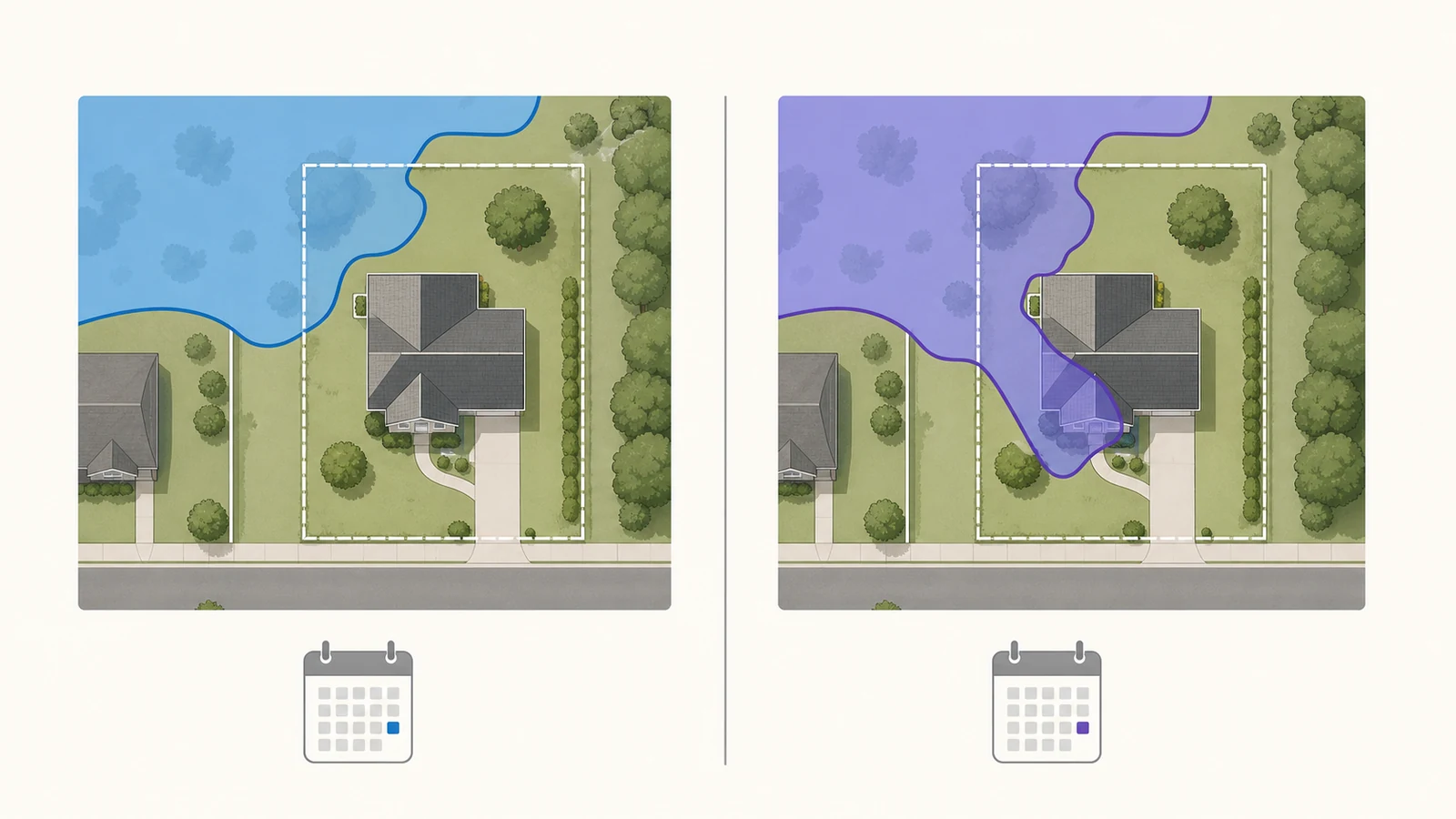
The effective FEMA flood map is the map in force today for National Flood Insurance Program flood-hazard mapping and federal mandatory-purchase determinations. A preliminary or pending map shows a proposed update and can help you prepare, but FEMA says it is not yet effective and may still change. Compare both maps at the same building location, record the zone and Base Flood Elevation on each, and ask the local floodplain administrator which data the community uses for permits. Ask the insurer for pricing; a flood-zone label is not a premium quote.
Start with the FEMA Map Service Center address search for the current effective map. Then open FEMA’s Flood Map Changes Viewer to see whether preliminary or pending data is available for the same address. Flood Map Check is an independent guide; it does not issue or certify a flood-zone determination.
Which map controls today?
The labels describe different stages of a FEMA map update. Do not treat the newest-looking layer as if it automatically replaced the map that is legally effective.
| Map status | What it tells you | How to use it |
|---|---|---|
| Effective | The FEMA flood hazard data currently in force for the community, including incorporated revisions where available. | Use it for the current NFIP map result. Confirm insurance and lending decisions with the insurer or lender and permit decisions with the local floodplain office. |
| Preliminary | A proposed FIRM and Flood Insurance Study released for community and public review. | Use it to identify possible future changes and to participate in the review process. It is not the effective map. |
| Pending | Newer flood hazard data in a post-preliminary stage that has not yet become effective. | Use it for advance planning and confirm the expected effective date locally. FEMA’s viewer warning still treats pending data as not effective. |
FEMA’s Flood Map Changes Viewer instructions state that preliminary and pending National Flood Hazard Layer data is for awareness, review, and guidance. It cannot be used by itself for flood-insurance policy rating or a mandatory flood-insurance purchase requirement.
Compare the same building in FEMA’s two tools
Use the building footprint—not only the address pin or the center of the parcel—as your reference point. A large parcel can cross more than one flood zone, and an address search can land on a road centerline or another approximate location.
- Open the FEMA Map Service Center and enter the full street address. If the result is uncertain, search by city and state or by longitude and latitude, then recenter the map on the structure.
- Record the current map number, panel number, effective date, flood zone, Base Flood Elevation if one is shown, and whether the structure appears inside a regulatory floodway.
- Check “Changes to this FIRM” for revisions, amendments, and revalidations. A static panel shows the map as published; a later Letter of Map Change can affect a property without changing the old panel image.
- Open the Flood Map Changes Viewer. Search the same address, ZIP code, coordinates, or city and state.
- In the layer list, compare the Effective FIRM Panels with Preliminary NFHL, Pending NFHL, and Preliminary Changes Since Last FIRM when those layers are available.
- Use the Preliminary Map Comparison Tool to create a side-by-side report. Save the report together with the address, retrieval date, and the two map statuses.
- Contact the community floodplain administrator before using the result for construction, substantial improvement, or a permit. Ask which map and elevation data the local ordinance currently applies.
FEMA’s official Map Service Center training distinguishes the address search, which finds the current effective map, from “Search All Products,” where preliminary and historic products may be available. It also notes that an official FIRMette cannot be made from a preliminary panel because that panel is not yet effective.
Record the change, not just the color
A useful comparison says exactly what changed at the structure. “The parcel turned blue” is not enough. Save the details that another person—an official, surveyor, lender, or insurance agent—can verify.
- Zone boundary: Did the building move into or out of a Special Flood Hazard Area, or did only another part of the parcel change?
- Zone designation: Did the label change, for example from X to AE, or from AE to VE?
- Base Flood Elevation: Is a BFE newly shown, removed, or changed? Record the elevation datum as well as the number.
- Floodway: Did the regulatory floodway boundary move across the site or proposed work area?
- Panel and date: Save both panel identifiers and label each one Effective, Preliminary, or Pending.
- Existing map change: Note any LOMA, LOMR, or revalidation tied to the property. Do not assume a prior determination appears as a visible change on every preliminary layer.
If the preliminary layer is unavailable, that does not prove the property is unchanged or has no flood risk. FEMA notes that not every layer is available for every location. Check “Search All Products” for the community and ask the local floodplain administrator whether a study is underway.
If the proposed map shows higher flood risk
A preliminary change does not create a federal mandatory-purchase requirement before the map becomes effective. It is still a useful warning. If the building moves into a Special Flood Hazard Area, the BFE rises, or the floodway moves onto the site, take these actions before the effective date:
- Ask the local floodplain office for the map-update schedule, expected effective date, and the ordinance or “best available data” rule used for permits.
- Ask an insurance professional how the proposed change could affect coverage and timing. A map comparison is not a premium quote.
- If a mortgage is involved, ask the lender which effective flood determination it is using today and what document it will require after a new map takes effect.
- For planned construction, give the effective map, preliminary map, and any elevation information to the local permitting office before design decisions become expensive to change.
The reverse also needs care. If a preliminary map shows lower risk, do not assume current insurance or permit requirements have ended. The effective map remains the federal map in force until the new map becomes effective, and a building-specific lender determination may require its own review.
If that disagreement is with the lender’s placement of the building on the current effective map—not with FEMA’s proposed map—use our FEMA Letter of Determination Review guide to check the joint request and 45-day filing window. An LODR is separate from the community’s preliminary-map appeal process.
If you think the preliminary map is wrong
Start with the community official handling the map update, not a general FEMA inbox. FEMA’s property-owner appeals guide explains that written appeals and comments are collected by the community during the formal review process and forwarded to FEMA.
An appeal is not simply a statement that the map seems unfair. It challenges proposed or modified flood elevations, flood depths, Special Flood Hazard Area boundaries, zone designations, or regulatory floodway boundaries with scientific or technical information. FEMA’s supporting-data guide describes the documentation expected from property owners. Other corrections—such as a road name, corporate boundary, or non-technical map feature—may be handled as comments.
- Confirm that a formal review or 90-day appeal period is open for the community.
- Ask the local floodplain administrator which proposed feature is appealable and where the community wants the package delivered.
- Identify the exact panel, parcel or structure, disputed boundary or elevation, and the preliminary FIS material involved.
- Use a qualified surveyor or engineer when the objection depends on elevations, hydrology, hydraulics, or topography.
- Submit before the local deadline and keep proof of delivery. The community may need time to review and forward the material before FEMA’s deadline.
Local permit rules can use newer data differently
FEMA’s national status label does not replace the local floodplain ordinance. A community may direct permit applicants to newer, more restrictive information as “best available data” even while the current FEMA map remains effective for federal insurance-map purposes.
For example, the official Utah Flood Hazards mapping FAQ tells readers to compare effective maps with newer preliminary or engineering data and explains when more restrictive information may be used locally. That is a Utah example, not a rule to copy nationwide. Ask the floodplain administrator for the rule that applies to your jurisdiction and project.
What this comparison does not prove
The two-map check documents mapped FEMA flood hazards at a point in time. It does not guarantee that a property will or will not flood, replace a survey or Elevation Certificate, decide a permit, quote an insurance premium, or override a lender’s flood determination. FEMA FIRMs also do not show every source of flooding, such as every drainage, stormwater, dam, or future-climate scenario.
For the current address workflow, use our FEMA flood map check by address. If you need the panel identifier and title block, see the FEMA FIRM panel guide. Check the flood map update date guide when the main question is whether a panel is current, and use the LOMA and LOMR-F lookup guide for a property-specific map-change letter.
Related official record checks
- FEMA Map Changes Since Last FIRM: Read the Comparison Report by Address
- Use FEMA's Flood Map Changes Viewer to Check a Community Map Revision
Use the guide that matches the exact agency, jurisdiction, tool, product, program, or record type; verify the live official source before acting.
Questions about changing FEMA maps
Does a preliminary FEMA map change my flood zone today?
No. A preliminary map shows a proposed change and is not yet the effective FEMA map. It can still affect planning, and a local permit office may direct you to newer data under its own ordinance.
Can a lender require flood insurance from a preliminary map?
FEMA says preliminary and pending NFHL data cannot be used for the federal mandatory-purchase determination. A lender may have separate risk or insurance conditions, so ask the lender which determination and map date it is using.
Why is there no preliminary layer for my address?
Not every location has preliminary or pending data in the viewer. Search all products for the community and contact the local floodplain administrator to learn whether a study exists, is still in development, or covers a different jurisdiction.
What is the difference between an appeal and a LOMA?
An appeal challenges proposed hazard information during a preliminary-map review period. A Letter of Map Amendment addresses how an individual structure or legally described parcel relates to an effective map. They occur at different stages and require different evidence.
Should I compare the whole parcel or the house?
Record both, but locate the building footprint precisely. A flood-zone boundary can cross an otherwise large parcel without crossing the structure, and insurance, lending, and permit questions may depend on the building or proposed work area.
Last checked July 28, 2026. FEMA tools, map status, and local procedures can change. Recheck the effective date and community instructions before relying on a saved result.
Use the preliminary-map appeal route when the window is open
- How to Appeal a Preliminary FEMA Flood Map During the 90-Day Period — When the statutory review period is open, use the preliminary-map appeal guide to distinguish scientific or technical appeals from comments.
- FEMA LOMR vs CLOMR: When a Project Needs a Map Revision Review — When one proposed project may change the map, use the CLOMR-versus-LOMR project-revision workflow.
- Floodplain Development Permit and No-Rise Certificate: What to Check Before Building — Before work begins, confirm the local floodplain-development permit and whether a no-rise analysis is required.
Recheck permits and map letters after the effective map changes
- Is Your LOMA Still Valid After a New FEMA Map? Check the Revalidation Letter — When a revised map becomes effective, check whether an earlier Letter of Map Change was incorporated, revalidated or needs review.
Related insurance and compliance checks
- Newly Mapped Into a FEMA High-Risk Flood Zone: Insurance and Lender Steps — When the revised FIRM becomes effective and moves the building into an SFHA, use the Newly Mapped insurance and lender workflow.