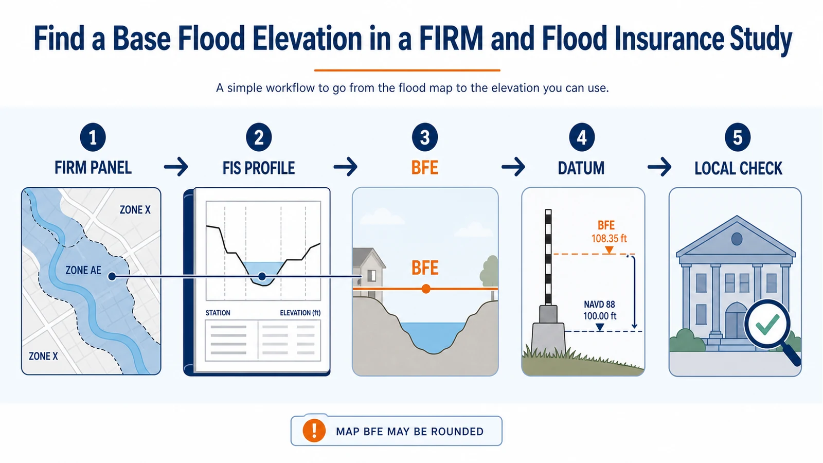
To find a Base Flood Elevation, locate the building on the effective FEMA Flood Insurance Rate Map, then open the matching Flood Insurance Study. In a detailed riverine area, use the FIRM to identify the flood source and nearby cross sections, transfer that location to the FIS flood profile, and read the 1%-annual-chance water-surface elevation. Cross-check the Floodway Data Table, record the vertical datum, and use a different method for a coastal zone or an approximate Zone A with no BFE. Have the local floodplain administrator verify the value before design or permitting.
FEMA defines a Base Flood Elevation (BFE) as the elevation of surface water produced by a flood that has a 1% chance of being equaled or exceeded in any given year. It is a water elevation tied to a stated datum, not depth above a particular floor.
| What the effective map shows | Where to look next | Do not assume |
|---|---|---|
| Detailed riverine Zone AE or an older A1-A30 zone | FIS flood profile and, where available, the Floodway Data Table | A whole-foot label on the panel is the precise value at the building |
| Detailed coastal Zone VE or coastal AE | FIRM zone elevation plus the FIS coastal stillwater and transect information | A riverine stream-profile interpolation applies |
| Approximate Zone A with no BFE | Local floodplain administrator and the best available local, state, or site-specific study | A neighboring Zone AE elevation can simply be carried into the site |
| Zone AH or AO | The mapped BFE or flood depth, legend, FIS, and local instructions | A depth above ground is the same thing as an elevation on a vertical datum |
Start with the effective panel, not the first map layer you see
Search the address in the official FEMA Flood Map Service Center. Recenter the result on the building footprint rather than trusting an address pin or parcel center. Save the community number, full FIRM panel number and suffix, effective date, flood zone, named flood source, nearby BFE lines, and any lettered cross sections. The FEMA address-check guide covers the location check, while the FIRM panel guide explains the panel identifiers and map details.
Use the effective product for the regulatory starting point. A preliminary panel can be useful for planning, but it is not silently interchangeable with the effective map. If both appear, label each saved file by status and follow the preliminary-versus-effective map check before reading an elevation.
- Confirm that the building, not just part of the parcel, is in the mapped zone.
- Write down the exact flood source name; a county FIS can contain many streams and coastal reaches.
- Note road crossings, bridges, stream confluences, and cross-section letters near the site. They will help match the FIRM to the profile.
- Check whether a revision or Letter of Map Change affects the panel or property before treating the original panel as the complete record.
Download the FIS report for the same community and map date
The FIRM is the mapped summary; the FIS report holds the engineering support, tables, and profiles behind it. FEMA’s FIS download instructions route users through Map Service Center Search All Products: search the jurisdiction or FEMA community ID, open Effective Products, find the FIS Report, and download the applicable file or volumes. Confirm that its community or county, effective date, and revision history fit the FIRM you saved.
A countywide study may be split into several volumes, with profiles placed near the end. Search the contents and PDF for the exact flood source name; do not stop at a similarly named creek in another municipality. Look for the vertical-datum section, flood profiles, Floodway Data Table, and, in coastal areas, stillwater or transect tables.
Match a riverine property to the 1% flood profile
In a detailed riverine study, the wavy BFE lines printed on the FIRM are selected whole-foot values. FEMA’s How to Read a Flood Insurance Study course says those map elevations are approximate values rounded to the nearest foot and that the flood profile is used to determine an accurate BFE for a location in a riverine floodplain. That distinction matters when a permit or design calculation depends on tenths of a foot.
A flood profile is a side view along a stream. Its horizontal axis follows distance along the stream; its vertical axis shows elevation. The profile normally includes the stream bed, lettered cross sections, bridges or culverts, and several probability lines. Find the line labeled 1% annual chance, 100-year, or base flood. Do not accidentally read the 0.2%, 2%, 4%, or 10% line.
- Mark the building on the effective FIRM and identify the centerline of the mapped flood source.
- Trace a line from the structure’s upstream edge or corner toward the stream, perpendicular to the direction of flood flow, following the FEMA course method rather than the shortest screen distance.
- Choose a common reference visible on both records: a lettered cross section, road crossing, bridge, or confluence.
- Measure the along-stream distance from that reference to the site’s perpendicular line, using the map scale. Do not measure diagonally from the house to a cross section.
- Move the same along-stream distance from the matching reference on the FIS profile.
- At that stream station, read the elevation where it meets the 1%-annual-chance profile and record the value, flood source, profile panel, and datum.
Screen resolution, map scale, bends in the flow path, split flows, tributaries, and backwater can make a do-it-yourself reading unsuitable for construction. Near a confluence, structure, abrupt profile change, or zone boundary, take the records to the local official or a qualified engineer or surveyor.
Use the Floodway Data Table as a cross-check
Where the FIS includes a Floodway Data Table, it reports results at the cross sections drawn on the FIRM. FEMA’s course directs readers to the Regulatory base-flood water-surface-elevation column for the accurate BFE at a listed cross section. If the building’s upstream corner aligns closely with a cross section, that table value may provide the applicable cross-section BFE without estimating between profile stations.
For a site between two cross sections, use the table as a reasonableness check: the profile value should generally fit between the regulatory BFEs immediately upstream and downstream. Read the column heading carefully. Older and newer tables can also show values without floodway, with floodway, and an increase; those are not automatic substitutes for the Regulatory column. A floodway table supports the profile reading and floodway analysis. It does not locate the building, establish a parcel boundary, or authorize encroachment.
Keep the BFE and building elevations on the same datum
An elevation number has no usable meaning without its vertical datum. FEMA studies may reference the National Geodetic Vertical Datum of 1929 (NGVD 29), the North American Vertical Datum of 1988 (NAVD 88), or another stated reference. The FIS identifies the datum used and may provide conversion information for earlier studies or map panels. Copy the datum every time you copy the BFE.
Do not compare a BFE in NGVD 29 directly with a lowest-floor elevation in NAVD 88. The numbers may look close while referring to different zero surfaces. A documented conversion must be applied before comparison, and the original value, converted value, conversion factor, and source should remain in the project record. For a permit or Elevation Certificate, let the responsible surveyor, engineer, or community official confirm that the conversion and benchmarks are acceptable.
Coastal zones and Zone A need different evidence
A riverine flood profile is not a universal BFE calculator. Use the mapped zone and flood source to choose the next evidence path.
- Coastal VE or coastal AE: Read the BFE shown for the coastal zone on the FIRM, then use the FIS coastal sections to understand the supporting stillwater elevation, wave effects, and transect data. FEMA’s FIS course explains that coastal BFEs may reflect storm surge, wave height, wave setup, and wave runup where present. Coastal zone elevations can represent mapped averages because of scale; do not interpolate them with a riverine stream profile.
- Approximate Zone A without a BFE: There is no hidden whole-foot value to extract from the panel. Detailed hydraulic analysis was not completed for that mapped area. Ask the local floodplain administrator which best available federal, state, local, or preliminary data the community accepts and whether a site-specific engineering analysis is required.
- Zone AH: The map generally shows a BFE for shallow ponding. Confirm the mapped value and datum with the FIS and local official rather than searching for a stream profile that may not exist.
- Zone AO: The map commonly shows flood depth above the ground rather than a conventional datum-based BFE. Follow the local rule for converting that mapped depth into a required design elevation; do not add it casually to an unverified ground reading.
- Zone X or D: The FIRM may not establish a regulatory BFE for the site. That absence does not prove there is no flood hazard and does not justify inventing an elevation from a nearby zone.
If you are unsure which branch fits the label, use the AE, VE, and X zone guide to separate zone meaning from the elevation-reading task.
Know where the map stops and a survey begins
The BFE describes the modeled water surface. An Elevation Certificate records surveyed information about a building and site, including relevant floor, grade, or equipment elevations under the form’s instructions. The certificate does not create the BFE, redraw a FEMA boundary, or by itself change a lender’s decision. The Elevation Certificate source guide explains where that separate document enters the workflow.
A qualified surveyor establishes the structure’s location and elevations on the required datum. A professional engineer may be needed to determine a BFE in an approximate Zone A or resolve complex hydraulic conditions. The community floodplain administrator applies the effective map, FIS, local ordinance, adopted freeboard, and accepted technical data to a permit question. These roles overlap, but none can be replaced by enlarging a map screenshot.
Take a reproducible record to the local official
- Property address, parcel identifier, and a marked building footprint.
- Effective FIRM panel number, suffix, date, flood zone, and flood source.
- FIS title, volume, effective or revision date, profile panel, and nearby cross sections.
- Candidate BFE, the method used to locate it, and the vertical datum.
- Any preliminary map, LOMC, local study, Elevation Certificate, or survey that may affect the answer.
Ask one precise question: “Which BFE and datum does this community require at this building location for this permit or review?” Also ask whether the ordinance adds freeboard or uses stricter local standards. Freeboard is a required margin above the BFE in some rules; it is not part of the BFE itself.
Related official record checks
- Find the Correct FEMA Flood Insurance Study Report for a Community
- How to Read a FEMA Flood Insurance Study Profile Before Using Its Elevation
- NAVD 88 vs NGVD 29 on a Flood Map or Elevation Certificate
- Flood Zone A With No BFE: Find the Best Available Official Elevation Data
- Base Flood Elevation vs Design Flood Elevation: Which Number Controls the Project?
Use the guide that matches the exact agency, jurisdiction, tool, product, program, or record type; verify the live official source before acting.
Questions that come up after the map check
Is the number printed inside Zone AE the exact BFE for my house?
Not necessarily. On a detailed riverine FIRM, selected BFE lines are generally rounded to whole feet. Use the matching FIS flood profile for the location-specific study elevation and verify it locally when tenths of a foot matter.
Can I subtract ground elevation from the BFE to get flood depth?
Only after the ground elevation and BFE are confirmed at the same location and on the same vertical datum. A coarse online terrain value is not a substitute for a survey when the result affects a building or permit.
Why does the Floodway Data Table show several water elevations?
The table can include Regulatory, without-floodway, with-floodway, and increase columns for different parts of the analysis. Match the cross section and use the Regulatory BFE for the mapped regulatory value unless the applicable FIS or local official directs otherwise.
What if the FIS profile does not include my stream?
Confirm the flood source spelling, FIS volume, panel status, and whether the area was studied by detailed methods. An approximate Zone A may have no profile or published BFE. Ask the community which best available data or engineering method it accepts.
Does finding the BFE prove the building complies?
No. Compliance depends on verified building elevations, the correct datum, the effective map and revisions, local freeboard and ordinance requirements, the building type, and the scope of work. The BFE is one input to that decision.
Official FEMA definitions, Map Service Center paths, and FIS-reading guidance were checked July 28, 2026. Flood maps, revisions, local ordinances, and accepted elevation data can change. Flood Map Check provides routing and interpretation, not surveying, engineering, insurance, or permit approval.
Use the next official workflow
- FEMA Flood Vent Requirements: How to Check Openings Below the BFE — After establishing the BFE, use the flood-opening guide for below-BFE enclosures and local inspection evidence.
Related insurance and compliance checks
- FEMA Floodproofing Certificate: When a Non-Residential Building Needs It — For eligible non-residential dry floodproofing, the BFE is only the starting elevation; the certificate and adopted design standard control the documented elevation.