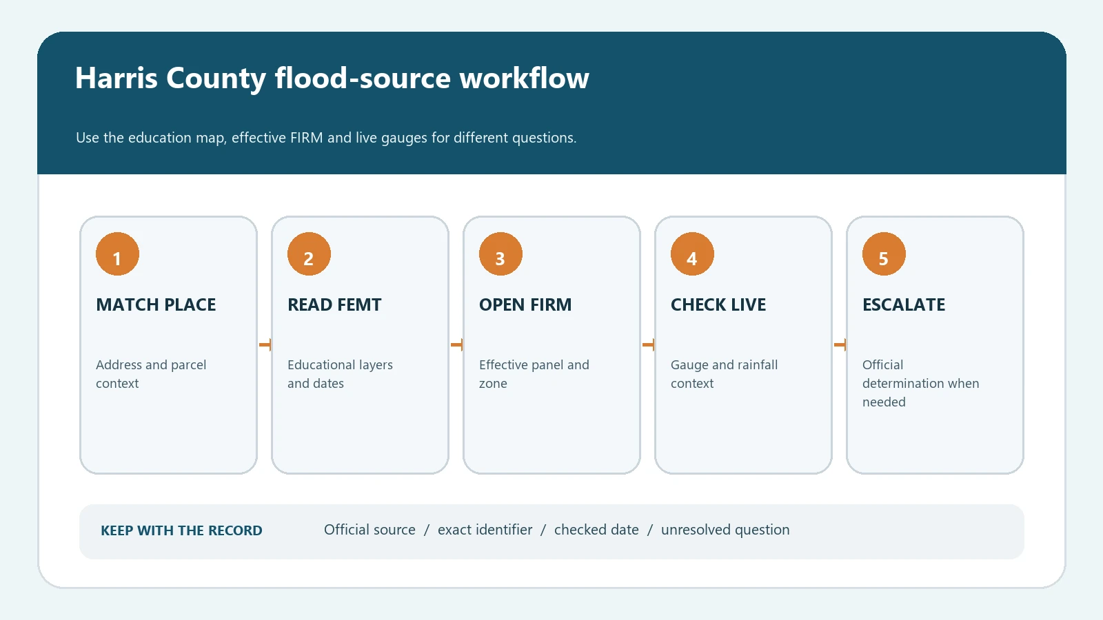
To check a Harris County flood map by address, start with the Harris County Flood Education Mapping Tool, match the correct location, and record the mapped floodplain and floodway layers. Then verify the effective Flood Insurance Rate Map in FEMA’s Map Service Center. Use the county Flood Warning System only for current rainfall and stream-level conditions. These tools answer different questions, and none of them alone is a survey, an insurance determination, or a guarantee that a property will or will not flood.
The Harris County Flood Control District describes its Flood Education Mapping Tool, or FEMT as a way to view mapped floodplains relative to homes, businesses, and other structures. The district also says FEMT is not the effective FIRM and directs users to the FEMA Map Service Center for that record. Keeping those roles separate is the central control in a reliable Harris County address check.
Choose the map that answers the question you actually have
A person checking a home purchase, a lender letter, a construction plan, or a storm happening today may use the phrase flood map for four different jobs. Starting in the wrong tool produces a result that can look precise while answering the wrong question. Use the county map to understand local layers, FEMA for the effective regulatory map, the warning system for live conditions, and the local floodplain administrator or a qualified professional when a formal decision is required.
| Official source | Use it for | Record from the result | Do not treat it as |
|---|---|---|---|
| Harris County FEMT | Address context, mapped floodplain, floodway, watersheds, channels, and ponding layers | Address selected, layer names, map date or disclaimer, and screenshot time | The effective FIRM, a survey, or a legal flood-zone determination |
| FEMA Map Service Center | Effective, preliminary, and historic FEMA products and a printable FIRMette | Community, panel number, suffix, effective date, and map product | A prediction of every possible source of flooding |
| Harris County Flood Warning System | Current rainfall totals and stream or channel gauge readings | Gauge name, observation time, parameter, and reading | A parcel flood-zone lookup or a promise that a road is passable |
| Local floodplain administrator | Permit questions, official local interpretation, and property-specific next steps | Office, contact date, question asked, and written response | A replacement for FEMA documents, title evidence, or an elevation survey |
If the search is outside Harris County, return to the FEMA flood map by address guide instead of assuming the same county tool or layer names apply. Local GIS portals use different update schedules, parcel sources, and disclaimers.
Match the address before reading colors or boundary lines
Enter the complete street address in FEMT and inspect the selected point before interpreting a layer. A Houston mailing address can be inside a different municipality or an unincorporated part of Harris County. Large sites can contain several parcels or buildings, and autocomplete can land on a nearby road segment. Compare the street number, street name, city, ZIP code, visible building footprint, nearby roads, bayou or channel, and parcel context. If the property boundary determines a purchase or building decision, obtain appropriate parcel and survey evidence rather than measuring the public web map.
| Evidence field | What to save | Why it prevents a bad conclusion |
|---|---|---|
| Search input | The exact address as entered | Makes the lookup reproducible and exposes spelling, unit, or ZIP errors |
| Selected location | Map pin, visible structure, roads, and nearby waterway | Confirms that autocomplete did not select a neighboring property |
| Mapped layers | Every enabled floodplain, floodway, ponding, watershed, and channel layer | Prevents one color from being reported without its layer definition |
| FEMA identifiers | Community number, panel, suffix, and effective date | Connects the county view to the correct federal map product |
| Checked time | Date, time, source URL, and tool version or disclaimer date when shown | Distinguishes a historical screenshot from a current lookup |
| Open question | Boundary uncertainty, structure elevation, map amendment, or permit issue | Keeps an unresolved issue from turning into an unsupported yes or no |
Do not publish a private resident’s name, phone number, insurance document, or nonpublic transaction notes as part of the evidence file. The useful record is the public map path and the fields needed to repeat the check, not a dossier about the occupant.
Read FEMT layers as separate evidence, not one risk score
FEMT can display mapped floodplains, a floodway, watersheds, channels, and ponding information. Each layer has a different purpose. A floodway is a regulatory part of the floodplain associated with carrying floodwater. The one-percent and 0.2-percent annual-chance areas are mapped probability standards, not a schedule saying a flood happens once every 100 or 500 years. Ponding identifies a different local condition and should not be reported as if it were a FEMA flood zone.
| Layer or label | Practical reading | Next check |
|---|---|---|
| Floodway | A mapped area where development can affect flood flows and is tightly regulated | Check the effective FIRM and ask the applicable floodplain administrator about the proposed work |
| 1% annual-chance floodplain | An area mapped for the flood event with a one-percent chance in any given year | Record the FEMA zone, panel, effective date, and base flood elevation information when available |
| 0.2% annual-chance floodplain | A lower-probability mapped flood area, often called the 500-year floodplain | Do not describe it as no risk or assume insurance and building questions are settled |
| Ponding | A local indication of places where stormwater can collect | Use local drainage and storm information; do not convert the layer into a FEMA zone |
| Watershed or channel | The drainage system and waterway context around the selected location | Use it to choose relevant gauges and local project information, not to certify a parcel |
The general Flood Zone AE, VE, and X guide helps with federal zone labels. Keep that interpretation separate from Harris County’s local ponding, watershed, and warning layers.
Verify the effective FIRM and keep its date attached
After the county lookup, search the same location in FEMA’s Map Service Center. Confirm the community and panel rather than downloading the first map returned for a place name. Save the panel number, suffix, effective date, and the location of the structure on the panel. If a Letter of Map Revision has changed the effective information, keep that document with the base panel instead of erasing the history.
- Open the FEMA Map Service Center and search the complete address.
- Confirm that the map point and community correspond to the Harris County location you checked.
- Open the effective map product and record the FIRM panel number, suffix, and effective date.
- Create or save a FIRMette when a compact reproducible map excerpt is useful.
- Review listed amendments or revisions when the property record, lender document, or county map suggests a later change.
- Escalate a material boundary or elevation question to the proper local office, surveyor, engineer, insurer, lender, or counsel.
Our FEMA FIRM panel and FIRMette guide explains how to preserve panel identifiers. A FIRMette is easier to share, but it does not gain a different legal status simply because it is cropped around the property.
Keep live rainfall and stream gauges out of the zone determination
The Harris County Flood Warning System reports current rainfall and stream or channel levels from gauges. It is useful during a weather event and for understanding nearby observed conditions. It does not change the FEMA zone printed for a parcel, and a low reading at one gauge does not establish that every street, drainage system, or structure is safe. Record the observation time because a live reading becomes stale quickly.
| Question | Correct source | Evidence to retain |
|---|---|---|
| What regulatory flood zone is mapped here? | Effective FEMA FIRM, checked against the county context | Panel, suffix, effective date, zone, and map location |
| What local floodplain or ponding layers are near the address? | Harris County FEMT | Selected address, enabled layers, legend, and checked date |
| What are gauges reporting now? | Harris County Flood Warning System | Gauge, parameter, reading, and observation timestamp |
| May a project proceed? | Applicable permitting authority and current rules | Project scope, official response, permit record, and professional evidence |
| Will the property flood? | No single map can answer this with certainty | State the mapped evidence and remaining hazards without a guarantee |
A property outside the mapped floodplain can still flood
Harris County’s official flooding FAQ explains that not every flood hazard, bayou, or creek is mapped and that intense rain can overwhelm local street drainage, causing ponding or overland flow. A boundary on a FIRM is therefore not a wall. Report the mapped zone accurately, but do not translate Zone X or a location outside the one-percent floodplain into flood-free, insurance unnecessary, or safe for every storm.
Likewise, a location inside a mapped floodplain is not proof that a particular building has flooded before. Structure elevation, finished-floor height, drainage, construction, map amendments, and the event itself can matter. Historical claims, seller disclosures, elevation certificates, surveys, and inspection evidence answer different questions and should be kept as separate records.
Build a Harris County map record another person can reproduce
A strong evidence file is short enough to audit. It identifies the address, the exact official source, the layer or map product, its date, what was observed, and what remains unresolved. This is more useful than a colored screenshot with no legend or a sentence saying the house is not in a flood zone.
- Save the exact address and a note describing how the map location was confirmed.
- Capture the FEMT layer list and legend alongside the selected location.
- Record the FEMA community, panel, suffix, effective date, and zone separately.
- If live conditions matter, save the gauge name and observation timestamp, not only the number.
- Write one sentence stating what the sources do not establish.
- Recheck the live sources before a purchase, closing, permit filing, insurance decision, or published update.
For another city-specific example, see the NYC Flood Hazard Mapper versus FEMA map guide. The tools are not interchangeable, but the evidence discipline is the same: identify the source, match the place, preserve the date, and state the limits.
Harris County flood map questions
Is FEMT the official FEMA flood insurance map?
No. Harris County presents FEMT as an educational view of mapped floodplains and related local layers. The district directs users to FEMA’s Map Service Center for the effective FIRM.
Does Zone X mean the property cannot flood?
No. It describes mapped federal flood-hazard information, not every source of water. Harris County notes that ponding, overland flow, local drainage, and unmapped waterways can produce flooding outside the mapped one-percent floodplain.
Can a live gauge tell me whether my house is safe?
A gauge reports conditions at a monitored location and time. It does not measure every street, structure, drainage inlet, or source of flooding. Follow current emergency guidance and never use a web reading to justify driving through water.
What if the county map and my lender letter differ?
Preserve both records and compare the address, FEMA community, panel, effective date, zone, and any map-change document. Ask the lender or its determination provider to identify the evidence used, and use the applicable FEMA review or map-change process if the determination may be wrong.
Flood maps, revisions, local layers, and live conditions change. Verify the current official records before relying on a result. Last reviewed August 6, 2026.