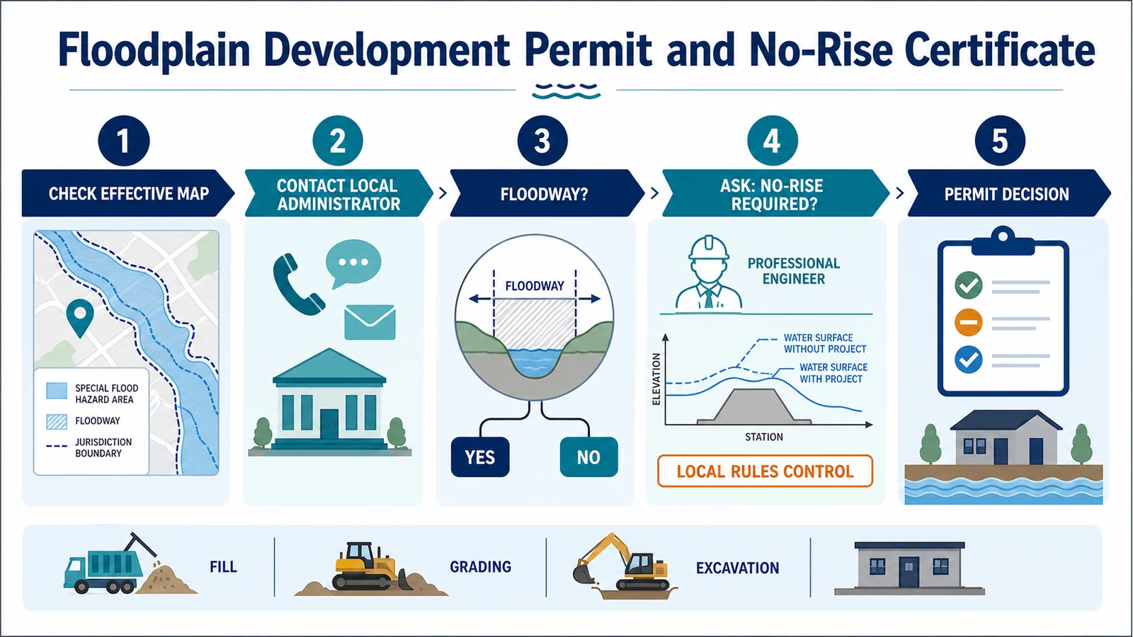
Before building, grading, placing fill, installing a culvert, or changing a channel in a mapped flood-prone area, ask the local floodplain administrator whether a floodplain development permit is required. A no-rise certificate is not required for every project in a Special Flood Hazard Area. It is commonly a local engineering submittal for an encroachment in an adopted regulatory floodway, where the National Flood Insurance Program minimum rule requires analysis showing no increase in base-flood levels. If the proposal would create a rise, it may need redesign or a community-coordinated Conditional Letter of Map Revision before the permit. The local ordinance, state standards, adopted map and study, and permit official control the checklist.
This guide covers the United States NFIP framework. It helps a project team prepare for local review; it does not issue a permit, certify an engineering result, or decide whether a design complies.
The permit question starts with every change to the site
Do not limit the first call to a new house or commercial building. 44 CFR 59.1 defines development broadly as a man-made change to improved or unimproved real estate. Its examples include buildings and other structures, mining, dredging, filling, grading, paving, excavation, drilling, and storage of equipment or materials.
That definition is why work smaller than conventional construction can need review. Fences, walls, driveways, utility trenches, stockpiles, demolition, and repairs can still need review. The local official decides whether the work needs an application, qualifies for a limited permit, or falls outside the regulated area.
- Describe temporary work as well as permanent work, including access roads, staging, spoil, and material storage.
- Show clearing, grading, excavation, fill, walls, fences, culverts, utilities, and drainage changes on the plan.
- Ask whether repair or renovation triggers substantial-improvement or substantial-damage review.
- Do not start site work merely because a separate building permit is not yet required.
An SFHA and a regulatory floodway are not the same area
The Special Flood Hazard Area is the mapped area subject to the base flood, commonly described as the 1-percent-annual-chance flood. A regulatory floodway is the channel and adjoining land reserved to carry that flood without cumulatively increasing the water-surface elevation more than the designated height. The floodway is normally a narrower, especially sensitive part of a riverine floodplain. Read the effective FIRM and Flood Insurance Study together rather than treating every shaded area as a floodway.
| Mapped situation | First permit question | Hydraulic question |
|---|---|---|
| Outside the FEMA SFHA | Does a local or state flood-hazard, drainage, setback, erosion, or unmapped-stream rule still apply? | Local data may control even when the effective FIRM does not show an SFHA. |
| SFHA, outside an adopted floodway | Which elevation, floodproofing, foundation, fill, drainage, and documentation standards apply? | A no-rise certificate is not automatically required solely because the site is in the SFHA. |
| Zone AE or A1-30 with BFEs but no adopted floodway | What cumulative-rise standard has the community adopted while no floodway is mapped? | The federal minimum in 44 CFR 60.3(c)(10) limits cumulative increase to no more than one foot; state or local rules may be stricter. |
| Adopted regulatory floodway | Will any proposed encroachment enter the floodway, and what does the local ordinance require? | The NFIP minimum requires standard-practice hydrologic and hydraulic analysis showing no increase, unless the conditional-revision path is completed first. |
Use the FEMA address map workflow to identify the effective product, then confirm its panel and date with the FIRM panel guide. If the zone label itself is unclear, the flood-zone guide separates common A, AE, VE, and X labels. These pages help assemble map evidence; the local authority still makes the permit decision.
The local floodplain administrator makes the permit call
NFIP rules establish minimum conditions for participating communities, but the community adopts and enforces the ordinance. 44 CFR 60.3 requires permit review for proposed construction or other development and requires the community to check for other necessary federal and state approvals. FEMA’s floodplain management resources for individuals likewise explain that state and local governments enforce the rules through zoning, subdivision, building-code, or special-purpose floodplain provisions.
Start with the community office that administers the property. The responsible official may work in planning, building safety, engineering, or a floodplain office. Ask for the current ordinance, application, submittal checklist, adopted FIRM and FIS, higher-standard maps, and reviewer. Request a written answer if the project is close to the SFHA or floodway boundary.
When a no-rise analysis may enter the file
For an adopted regulatory floodway, 44 CFR 60.3(d)(3) says the community must prohibit encroachments, including fill, new construction, substantial improvements, and other development, unless hydrologic and hydraulic analyses performed according to standard engineering practice demonstrate that the proposal would not cause any increase in flood levels during the base flood. The regulation states the performance test. It does not create one universal FEMA certificate form for every community.
FEMA’s current Floodway Analysis and Mapping guidance explains that this work is usually called a no-rise or zero-rise analysis. Many communities require the applicant to hire a qualified registered professional engineer, submit the analysis and supporting data, and provide a signed certification. The community remains responsible for reviewing the package and deciding whether the regulatory test is met; an engineer’s certification is evidence, not an automatic permit.
No-rise should therefore be treated as a project-specific question. Work wholly outside a regulatory floodway may still need a floodplain development permit, elevation data, drainage review, or a different hydraulic demonstration. Conversely, a tiny-looking floodway encroachment can require modeling because size alone does not establish that the effect is zero. Local ordinances may also use a more protective standard than the NFIP minimum or require state review.
The engineer and reviewer need a reproducible comparison
A signed statement without the analysis is usually not enough. The record should let the community reproduce how the project was added to the accepted flood model and where elevations were compared. FEMA guidance describes a sequence that preserves the effective analysis, documents corrections, represents existing conditions, and then adds the proposed work.
- Effective baseline: the model, FIS reach, floodway data, discharges, cross sections, and datum behind the effective mapping.
- Documented corrections: changes needed to run or reproduce the effective model, kept separate from the project itself.
- Existing conditions: current terrain, structures, channel geometry, and other accepted conditions before the proposal.
- Proposed conditions: every bridge, culvert, fill area, wall, grading limit, structure, or channel change represented as designed.
- Comparison outputs: water-surface elevations at existing and added cross sections, profiles, tables, floodway effects, model files, and a clear change log.
The engineer should confirm the model version, coordinate system, vertical datum, rounding convention, project reach, upstream and downstream transition, and the community’s required certification language before doing the final run. A technically sound analysis can still be rejected if it starts from the wrong effective model or omits files the reviewer needs.
Use this sequence before any work begins
- Define the entire scope. Include temporary access, staging, clearing, utilities, excavation, fill, drainage, and material storage, not only the finished structure.
- Locate the work on the effective map and study. Record the community number, panel, effective date, flood source, zone, BFE when available, floodway boundary, cross sections, and datum.
- Meet the floodplain administrator early. Ask which local and state standards, maps, models, setbacks, freeboard, application forms, and professional seals apply.
- Get the hydraulic trigger in writing. Confirm whether the project needs no-rise, another rise analysis, a floodplain study, state review, or no hydraulic model at all.
- Obtain the accepted model and instructions. Have the qualified engineer coordinate file format, model version, datum, comparison tolerance, certification wording, and review limits.
- Submit one coordinated permit package. Include site and grading plans, engineering data, property authorization, certifications, and evidence of other agency permits when applicable.
- Wait for written approval. A map screenshot, consultant email, draft analysis, or FEMA case number is not the local floodplain development permit.
- Build and close out to the approved record. Preserve inspections, approved revisions, as-built surveys or plans, occupancy or compliance documents, and any later map-revision requirement.
A modeled rise can move the project to a CLOMR
If an encroachment in an adopted floodway would increase base-flood elevations, redesign is often the first practical option. Under 44 CFR 60.3(d)(4), a community may permit such an encroachment only after it first follows the conditional FIRM and floodway revision requirements in 44 CFR 65.12 and receives FEMA approval. The project team may prepare the technical package, but it must coordinate the route, notices, assurances, and concurrence with the affected community.
FEMA’s LOMR and CLOMR page describes a CLOMR as a comment on a proposed project. It does not revise the effective map, authorize construction, or replace the community’s permit. If the project is built, certified as-built conditions may support a final Letter of Map Revision afterward. If a preliminary communitywide map is also in circulation, keep it separate from the current map by using the preliminary-versus-effective map guide.
Prepare an evidence packet the reviewer can keep
- Property address, parcel or legal description, owner authorization, applicant, engineer, and local contact.
- A plain-language project narrative and scaled plans showing existing and proposed conditions.
- Community and FIRM identifiers, effective date, flood source, zone, floodway status, BFEs, cross sections, and vertical datum.
- Survey, topography, grading and fill quantities, structure geometry, culvert or bridge data, and drainage details relevant to the analysis.
- Effective, corrected, existing, and proposed model files as required, plus profiles, tables, work maps, and a model-change log.
- The professional engineer’s signed and sealed analysis or certification when the jurisdiction requires it.
- Other federal, state, tribal, regional, or local permits and environmental documentation identified by the administrator.
- The issued permit, review comments, approved revisions, inspection record, and as-built or closeout documents.
A county example shows why the local checklist matters
Weld County, Colorado, currently distinguishes a limited floodplain permit for certain minor work from a Flood Hazard Development Permit for other SFHA development. Its public guidance says floodway work under the latter route requires a professional engineer to demonstrate plus-or-minus 0.00 feet of rise and stamp a no-rise certification, or the project must use a CLOMR route. That is a useful example of a local workflow, not a rule to copy into another county.
Your jurisdiction may use different names, thresholds, forms, review agencies, model standards, fees, and closeout documents. It may also regulate locally mapped flood hazards outside FEMA’s SFHA or impose stricter freeboard and cumulative-impact limits. Reopen the local page and ordinance when the design changes; an old permit packet may not reflect the current rule.
Avoid the shortcuts that cause permit delays
- Checking only the building footprint: access, grading, fill, utilities, walls, and staging can enter the regulated area first.
- Confusing the SFHA with the floodway: use the effective FIRM and FIS floodway information, not only the color at the address pin.
- Ordering a certificate before asking the reviewer: confirm the accepted model, method, signer, form, and standard before paying for analysis.
- Submitting only a sealed summary: the community needs enough supporting technical data to evaluate the conclusion.
- Treating a CLOMR as a permit: a conditional FEMA comment and a local authorization are separate records.
- Building a changed design: field revisions can invalidate the approved analysis and trigger new review or as-built map work.
What the permit and certificate do not prove
A floodplain development permit records a community decision under the submitted plans and applicable rules. A no-rise certification addresses a modeled flood-elevation effect under stated assumptions. Neither document proves that flooding cannot occur, establishes a property boundary, replaces structural or geotechnical design, sets an insurance premium, satisfies every environmental or waterway permit, or guarantees that future maps and site conditions will remain the same.
Related official record checks
- FEMA Floodway Data Table: Match Cross Sections, BFE, and Floodway Width
- Regulatory Floodway vs Floodplain: Check Both Before Planning Work
Use the guide that matches the exact agency, jurisdiction, tool, product, program, or record type; verify the live official source before acting.
Questions to settle before submitting
Does every project in Zone AE need a no-rise certificate?
No. Zone AE can include land outside an adopted regulatory floodway, and a community may use different standards where no floodway is mapped. Ask the administrator to identify the mapped condition and the exact local trigger.
Can a property owner sign the no-rise form?
The local form and state professional-practice law control. Hydraulic no-rise analyses are commonly prepared and certified by a registered professional engineer, but the reviewer should state the required credential and seal.
Does no-rise replace an Elevation Certificate?
No. A no-rise analysis addresses the project’s effect on modeled flood levels. An Elevation Certificate records building and elevation information for different compliance, mapping, or insurance uses. A project may need one, both, or neither depending on its scope and local rules.
Can site work begin while a CLOMR is pending?
Do not assume so. Where 44 CFR 60.3(d)(4) applies, the conditional revision and FEMA approval come before the community permits the rising floodway encroachment. Other local, state, or federal approvals may also be required before disturbance begins.
Sources checked July 28, 2026: current 44 CFR 59.1, 60.3, and 65.12; FEMA’s November 2023 Floodway Analysis and Mapping guidance; FEMA floodplain-management and LOMR/CLOMR resources; and Weld County’s current permit page. Recheck the community and official sources before design or filing.
Use the next official workflow
- Substantial Damage Determination After a Flood: The 50% Rule and What Happens Next — After damage, permanent repair permits may depend on the community's substantial-damage determination and local cumulative rules.
- FEMA Flood Vent Requirements: How to Check Openings Below the BFE — For crawlspaces, garages or enclosures below the BFE, verify flood-opening requirements before permit inspection.
Related insurance and compliance checks
- FEMA Floodproofing Certificate: When a Non-Residential Building Needs It — A non-residential dry-floodproofing proposal needs professional design certification, as-built inspection evidence and local permit acceptance.
- How to File an NFIP Increased Cost of Compliance Claim After Flood Damage — When a community enforces post-flood mitigation, keep the determination, permit, work and invoice records needed for a separate ICC claim review.