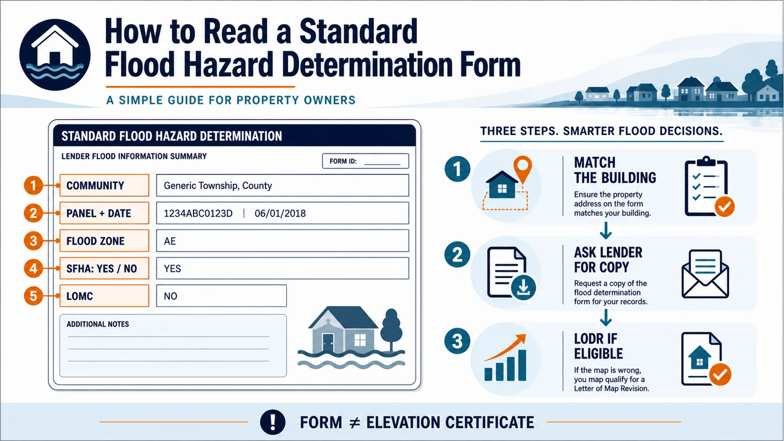
An SFHDF records the lender’s determination of whether the building or manufactured home securing a loan is in a Special Flood Hazard Area (SFHA). Confirm the collateral building, NFIP community, effective FIRM panel and date, any Letter of Map Change, flood zone, and final SFHA answer. The form is not a survey, Elevation Certificate, parcel-wide flood-risk report, or insurance quote.
The current FEMA-hosted form may look different in a lender portal because an electronic version need not copy the paper layout. The required fields still have to be present and the lender must be able to reproduce the form. Ask for a complete copy before trying to resolve a notice that only says flood insurance is required.
Match the fields before accepting the final box
The final determination makes sense only when the identity and map fields above it all describe the same building. Use this reading order instead of starting with the flood-zone code alone.
| SFHDF field | What to verify | Why it can change the result |
|---|---|---|
| Collateral description | The street address, legal description and specific building securing the loan | A parcel may contain several buildings or extend across more than one map area |
| NFIP community | Community name, county, state and six-digit community number | The community with land-use jurisdiction may differ from a mailing city or county label |
| Map panel and date | The complete FIRM map or community-panel number and effective or revised date | A correct address on the wrong panel or an obsolete panel can produce the wrong map-location decision |
| LOMC | Yes or no, plus the case number and date when available | A later FEMA letter may affect the building even when the printed panel has not changed |
| Flood zone | The zone at the building footprint, not merely somewhere on the tax parcel | A parcel can cross a zone boundary while the secured building remains on one side |
| SFHA determination | Yes or no for whether the building or manufactured home is in an A- or V-family SFHA | This is the form’s federal mandatory-purchase decision, not a statement that flooding is or is not possible |
Section I identifies the loan and the actual collateral
Start with the lender or servicer name, loan identifier and collateral description. The collateral field tells you what was located on the map. A postal address may not be enough for a rural property, a condominium project, a manufactured home, or land with multiple structures. Look for a legal description, parcel identifier, building number or attached schedule that removes the ambiguity.
Do not assume the optional insurance amount proves the flood determination is correct. The location decision and the amount of coverage are separate lender compliance steps. If the address describes the whole parcel but the loan is secured by one particular structure, ask the lender which footprint the preparer plotted and whether an attachment covers other buildings.
The NFIP community is a jurisdiction, not just a mailing place
Section II-A identifies the NFIP community whose map and participation status apply. Compare the community name, county, state and community number as a set. A property can use one city in its mailing address while lying in an unincorporated county, or it may have been annexed into a different jurisdiction. That distinction matters because the form is tied to the community with authority over the building, not whichever place name is most familiar.
44 CFR 65.16 defines the SFHDF’s purpose as determining whether the building or mobile home is in an identified SFHA, whether flood insurance is required, and whether federal flood insurance is available. Read Section II-C separately from the Section II-D location result: check community participation and program status, any “not available” selection, and any CBRA or OPA designation. If the community number conflicts with the panel prefix, flag it for the lender or determination provider.
The panel number and date must describe the effective map used
Section II-B should show the NFIP map number or community-panel number and the panel’s effective or revised date. Preserve the whole identifier, including its suffix. Then compare it with the effective products at the FEMA Map Service Center. The FIRM panel guide explains where to find the panel number, suffix and effective date without confusing a preliminary product with the map currently used for a federal lender determination.
A determination date and a panel effective date answer different questions. The determination date shows when the preparer completed the form. The panel date identifies the FEMA map used. An older determination is not automatically invalid: the 2022 revised interagency Q&A permits limited reliance on a previous SFHDF for certain transactions when the statutory conditions are met, including a determination no more than seven years old and no map revision or update affecting the property. A new loan by a different lender is treated differently. Ask the lender for its reliance basis instead of applying the seven-year rule yourself. Read optional Section E comments and Section II-F preparer details for explanations and the right correction contact.
A checked LOMC box needs a case-level check
The LOMC field asks whether a FEMA Letter of Map Change affects the building, with a case number and date when available. “Yes” does not, by itself, say that the building was removed from the SFHA. Read the actual FEMA letter, exhibits, effective language and building or parcel description. Confirm that the case applies to this structure and has not been superseded, revalidated or incorporated into a later map.
A LOMA, LOMR-F and project-level LOMR can have different evidence and effects. Use the LOMA and LOMR-F lookup guide to identify the letter before treating the LOMC checkbox as a complete conclusion. If the form says “No” but you have a FEMA case number, send the letter to the lender and ask the preparer to document whether it applies to the secured building.
Flood zone and SFHA yes-or-no are related but not interchangeable
The flood-zone field records the map zone at the building. The determination field then asks whether the building or manufactured home is in an SFHA, identified on the form as zones containing the letters A or V. If any part of the secured building crosses the mapped SFHA boundary, the form can show “Yes” even when most of the building or parcel appears outside it. Zone X does not mean zero flood risk; it means the federal mandatory-purchase test shown on this form is not triggered by an A- or V-family SFHA location.
Do not use a zone disagreement between this form and an insurance document as automatic proof of error. The FDIC manual notes that NFIP Risk Rating 2.0 premiums are no longer determined by flood zone, so the policy and the SFHDF serve different functions. The map-versus-insurance guide separates the lender’s mandatory-purchase decision from premium rating and broader flood risk.
The form follows the building, not the outer parcel line
This is the most common reading mistake. A shaded SFHA somewhere on the parcel does not necessarily put the secured building in the SFHA, and an unshaded parcel centroid does not prove the building is outside. The legal question described in 44 CFR 65.16 is the location of the building or mobile home. Compare the actual building footprint with the mapped boundary and make sure a driveway, detached garage, vacant acreage or neighboring roof was not used as a substitute.
When several buildings secure one loan, expect building-level determinations or an attachment that makes each result clear. Ask which structure produced the “Yes” answer. Do not redraw a boundary from a small portal image; request the technical data or marked panel that shows the location used by the preparer.
Ask for the form and source material in one request
The FDIC Flood Disaster Protection Act manual incorporates the current interagency flood-insurance Q&A. It says a lender may provide the SFHDF to a borrower, the borrower does not have to sign merely to acknowledge receipt, and the lender would need to make the determination available under FEMA’s LODR process. A separate notice tells the borrower about the SFHA and insurance requirement; the SFHDF does not replace that notice.
- a complete, legible SFHDF, including any continuation page or multi-building schedule;
- the dated Notice of Special Flood Hazards or other lender notice that started the insurance requirement;
- the exact FIRM panel, effective date and marked building location used by the preparer;
- any LOMC case number, letter and exhibit considered in the result;
- the determination provider’s contact information and the lender contact authorized to correct the loan file.
Keep the request factual. Identify the field that conflicts with your documents and ask which source controlled it. Do not alter the lender’s form, cancel required coverage or rely on an unofficial map pin while the lender reviews the discrepancy.
Triage an apparent error before choosing a FEMA process
- Wrong building or address: ask the lender to confirm the secured structure and the point or footprint sent to the determination provider.
- Wrong community or panel: compare the jurisdiction, full panel number, suffix and effective date with FEMA’s effective products.
- Missing LOMC: provide the FEMA letter and case number, then ask whether it applies to this building and current map.
- Parcel-versus-building mismatch: request the marked map and technical data showing the building footprint used.
- Elevation argument: stop. The SFHDF location review is not the place to decide floor elevation, natural ground elevation or a new map amendment.
- Insurance-price disagreement: separate the mandatory-purchase location decision from policy rating and coverage questions.
Use the 45-day LODR route only for the lender’s map-location decision
If the lender notified you that the building is in an SFHA and flood insurance is required, and the dispute is whether the building was located correctly on the effective map, the borrower and lender may jointly request a FEMA Letter of Determination Review. Under 44 CFR 65.17, the joint request must be postmarked within 45 days of the lender’s notification and signed by both parties. The regulation requires the completed SFHDF, the lender’s notice, the technical data used, and the effective map panel marked with the building location. Elevation data are not considered.
FEMA’s current LODR fact sheet and the step-by-step LODR guide cover eligibility, the joint filing package and FEMA’s response. Use that page for filing details; this article’s job is to help you identify the disputed SFHDF field. Recheck FEMA’s current fee and delivery instructions before sending anything.
An Elevation Certificate answers a different question
An Elevation Certificate records surveyed elevations and building characteristics for floodplain management, insurance or map-change uses. The SFHDF records a lender’s map-location determination. A finished-floor elevation cannot repair a wrong address or wrong panel, and 44 CFR 65.17 expressly excludes elevation data from an LODR. If the evidence depends on natural ground elevation or fill, ask whether a LOMA or LOMR-F process is appropriate instead of trying to convert the lender form into an elevation appeal.
What the SFHDF does not prove
A correctly completed SFHDF does not certify that a property is safe from flooding, establish a surveyed boundary, set a Base Flood Elevation, approve a building permit, calculate an NFIP premium, guarantee insurance availability in every circumstance, or change the FEMA map. It records the lender’s federal flood-hazard determination for the identified collateral and map information.
Flood Map Check is an independent source-routing and interpretation guide, not FEMA, a lender, an insurer or a surveyor. Keep the original form, notice, marked panel, LOMC documents and all written corrections with the loan file. A later map update, refinance, transfer or new building can require a different determination.
Questions borrowers often have
Can I ask for the SFHDF even if it was not sent with the notice?
Yes, ask the lender or servicer for it. The interagency Q&A says providing a copy is permitted, and the lender must make the determination available when the borrower and lender use FEMA’s LODR process. Also request the technical source used to place the building on the map.
Does “No” mean I do not need flood insurance?
It means the form did not place the building in an A- or V-family SFHA for the federal mandatory-purchase test. It does not mean the property cannot flood, and a lender may have separate contractual risk requirements. Ask the lender and insurance professional about the specific loan and coverage.
Does a LOMC “Yes” box automatically remove the building?
No. The checkbox says a Letter of Map Change was considered. The case letter and exhibits determine which building or land it affects and what FEMA decided. Verify the case number, effective language and current map context.
Should I wait for FEMA before keeping required coverage?
No. A correction request or LODR filing does not itself suspend the lender’s requirement. Keep coverage in force unless the lender and insurer give written instructions after the determination is resolved.
Sources checked July 28, 2026: FEMA Form FF-206-FY-21-116, current 44 CFR 65.16 and 65.17, the 2022 Revised Interagency Questions and Answers Regarding Flood Insurance, the FDIC Flood Disaster Protection Act examination manual, FEMA’s LODR fact sheet and the FEMA Map Service Center. Electronic layouts and administrative instructions can change, so verify the lender’s current form and FEMA’s live filing instructions when you act.
Use the next official workflow
- Is My Community in the NFIP? Check Participation and CRS Class — Use the community identification details on the lender form to verify NFIP participation and the separate CRS class.
- CBRS Property Map Check: Get Official Documentation — If the lender form references CBRS or an OPA, obtain the appropriate USFWS mapper documentation or property determination.
Related insurance and compliance checks
- Newly Mapped Into a FEMA High-Risk Flood Zone: Insurance and Lender Steps — If the lender form reflects a newly effective SFHA, compare the prior and current zone records before asking the insurer to verify Newly Mapped eligibility.