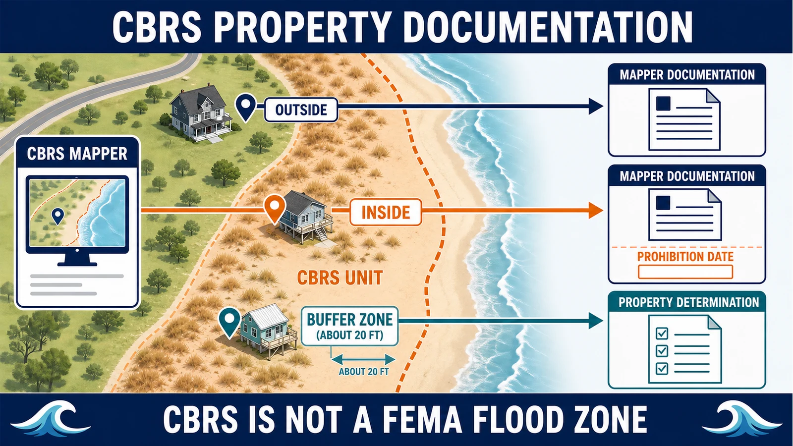
To document whether a coastal property is inside or outside the Coastal Barrier Resources System, use the U.S. Fish and Wildlife Service CBRS Mapper and Validation Tool. Generate the self-service “CBRS Mapper Documentation” when the point is clearly inside or outside. If the tool places the location in the approximately 20-foot CBRS Buffer Zone, or a structure is crossed by the boundary, request an official CBRS Property Determination from the Service. A FEMA flood zone, FIRM, or LOMA does not establish or change a CBRS boundary.
Last checked: July 29, 2026. CBRS maps can be revised by law, and federal flood-insurance eligibility can depend on the unit type, prohibition date, structure location, construction history, and current NFIP rules. Use current Service documentation and obtain an eligibility decision from the flood-insurance provider.
CBRS status is a federal-program question, not another flood-zone label
The Coastal Barrier Resources Act created the John H. Chafee Coastal Barrier Resources System along portions of the Atlantic, Gulf, Great Lakes, Puerto Rico, and U.S. Virgin Islands coasts. The system has two unit types: System Units and Otherwise Protected Areas. According to the Service’s federal flood insurance and CBRA guidance, most new federal expenditures and financial assistance are restricted in System Units, while the federal flood-insurance restriction is the principal restriction in OPAs.
That is different from a FEMA Special Flood Hazard Area. The FIRM shows mapped flood hazards and insurance zones; the CBRS map shows a statutory coastal-barrier boundary administered by the Department of the Interior through the Service. A property can raise both questions, but one map cannot answer the other. Use the site’s coastal flood-map comparison for hazard layers, then use the Service’s mapper for CBRS status.
Choose the documentation route shown by the mapper
| Mapper result | Next document | Who handles it |
|---|---|---|
| Clearly outside the CBRS | Generate and save CBRS Mapper Documentation | Property owner, surveyor, lender, agent, or other user through the Validation Tool |
| Clearly inside a System Unit or OPA | Generate documentation showing the unit and applicable prohibition date information | Validation Tool first; insurer decides federal flood-insurance eligibility |
| Inside the CBRS Buffer Zone or structure is bisected | Request an official CBRS Property Determination letter | U.S. Fish and Wildlife Service after reviewing location evidence |
| Insurance agent needs a buffer-zone determination | Route through NFIP Direct or the Write Your Own insurer | Insurer submits through the NFIP Bureau and Statistical Agent to the Service |
| Federal project or funding consultation | Property documentation may be only the location step; a separate CBRA project consultation may be needed | Responsible federal funding agency and the Service |
The Service’s CBRS property documentation page is the controlling process guide. It says the Validation Tool may be used by property owners, surveyors, real estate professionals, federal agencies, and others. It also sets a different submission route for insurance agents, so an agent should not bypass the insurer channel by sending the same request as a property owner.
Prepare enough location evidence before opening the mapper
An address pin can land on a road, parcel centroid, mailbox, or building that is not the structure at issue. That matters near a statutory boundary. Collect the exact property address, parcel number, assessor map, deed or survey if available, and a map that identifies the relevant structure. If the parcel contains several buildings, label the one tied to the mortgage, insurance application, project, or federal funding request.
- Property address and jurisdiction
- Parcel identification number and property record card
- Survey, plat, deed exhibit, or tax map that fixes the parcel and building location
- Name of the structure or project that needs documentation
- Existing determination letter, lender form, or insurer request if one triggered the check
- Construction or permit records that may later be relevant to the insurer’s eligibility review
The Service lists a property record card, survey, deed, map, and an Elevation Certificate as examples of additional location evidence for a formal determination. This is not an Elevation Certificate procedure: elevation data does not set the CBRS boundary. The document is useful only if it helps locate the property or structure.
Generate CBRS Mapper Documentation step by step
- Open the official CBRS Mapper from the Service’s maps and data page, not a copied coastal layer on a real-estate site.
- Search the address, then compare the result with the parcel and structure location. Reposition the point if the search marker does not identify the relevant building.
- Open the CBRS Validation Tool and place the validation point on the structure or project site that needs documentation.
- Review whether the result is inside, outside, or within the CBRS Buffer Zone. Do not move the point simply to obtain a cleaner answer.
- Generate the CBRS Mapper Documentation when the tool permits it. Save the PDF with the property address, date checked, unit number if shown, and the map date.
- If the tool reports the Buffer Zone, save that output and assemble the supporting documents for a formal determination.
The Service states that its digital boundaries are generally considered accurate to within approximately 20 feet of the boundary shown on the controlling official maps. That is why the mapper refuses to issue a simple in-or-out document in the Buffer Zone. The buffer is a quality-control route, not a third statutory unit type and not proof that the property is inside.
Read the output without turning it into an insurance decision
| Item on the documentation | Why it matters | What still needs confirmation |
|---|---|---|
| Inside or outside result | Documents the point’s relationship to the CBRS boundary | Whether the point accurately represents the insured structure or full project site |
| System Unit or OPA | Identifies the statutory unit category | Which federal restrictions and exceptions apply to the requested program |
| Unit number | Connects the result to the controlling official map | Whether a later official map superseded an older letter |
| Flood insurance prohibition date | Provides a date used in the NFIP eligibility analysis | Structure construction, permit, and substantial-improvement history |
| Official map date | Lets a reader check whether the determination used the current map | Whether Congress later adopted a revised CBRS map |
Do not confuse the prohibition date with the FIRM effective date, the official CBRS map date, or the building’s construction date. The Service defines it as the date on which the federal flood-insurance prohibition first took effect for that area. It is generally tied to when the area was first established as a System Unit or OPA, but it may differ. Save the exact prohibition date shown on the documentation; the insurer must compare it with the building’s permit, construction, and later-improvement history under the current rules.
Inside status is not automatically the complete answer to “Can I insure this building?” The Service explains that federal flood insurance is generally prohibited within the CBRS, with exceptions tied to matters such as the structure’s timing relative to the flood-insurance prohibition date and certain OPA uses. Current rules also contain special treatment for some structures affected by later map additions; the federal implementation rules are collected in 44 CFR Part 71. Give the documentation and construction records to the insurer; do not use a general web article to decide eligibility.
Likewise, outside status does not mean the property has low flood risk. It only answers the CBRS boundary question for the validated location. Check the effective FEMA map through the FIRM, panel, and zone workflow and review local coastal, storm-surge, erosion, and future-risk information separately.
Request a formal determination only for the buffer-zone case
The Service provides an official CBRS Property Determination for properties within about 20 feet of a boundary, including structures crossed by the line. Submit the address, the Validation Tool output showing the Buffer Zone, and enough parcel or survey evidence to fix the location. The Service’s process page gives the current email route for eligible requesters. Insurance agents must instead submit through NFIP Direct or the Write Your Own insurer handling the application.
The Service’s property determination FAQ says it does not charge a fee and generally completes a determination in two to three weeks, depending on workload and staff resources. Treat that timeframe as an estimate, not a closing guarantee. Request the letter early and ask the lender or funding agency what it will accept while the case is pending.
A FEMA LOMA cannot move the CBRS boundary
A LOMA or other Letter of Map Change addresses FEMA flood-map information. The Service’s FAQ explicitly says a CBRS boundary cannot be changed through a Letter of Map Amendment, and it says FEMA FIRMs are not used to place the CBRS boundary in an official determination. If a lender form contains both FEMA map fields and CBRS or OPA fields, verify each through its own agency route.
If the issue is a FEMA amendment or revision, use the site’s LOMA and LOMR-F case guide. If the issue is a CBRS line, use the Service’s documentation process. Sending a CBRS dispute to FEMA or a FIRM dispute to the Service delays both.
Check the structure, not merely the parcel shading
The Service explains that federal flood-insurance restrictions focus on the insurable structure. If an undeveloped part of a parcel is in the CBRS but the insurable structure is completely outside, the structure is not barred on that fact alone. The opposite mistake is also possible: a large parcel may look mostly outside while the building or planned project touches the unit. Validate the point that corresponds to the actual structure and retain a map showing how you placed it.
- For a purchase, identify every insurable structure and ask which one secures the loan.
- For a proposed project, validate the project footprint rather than a convenient address pin.
- For an insurer request, keep the Validation Tool document with the application and construction-date evidence.
- For a federal funding request, ask the funding agency whether separate CBRA consultation is required.
- For a lender notice, compare the CBRS field with the SFHDF field-reading guide before asking for a correction.
If an old letter or new map changes the picture
For an older inside determination, compare the unit number and official map date in the letter with the current CBRS Mapper. If the dates match, the FAQ says the letter remains current. An older outside letter does not contain a unit number, so contact the issuing Service office to ask whether a later map affects the property. Request a new determination if the controlling map changed.
The Service does not offer a formal appeal process for a property determination. A requester who believes the result is wrong may submit new location information and ask for reevaluation. Boundary modification is a different statutory process; disagreement with a result does not itself move the line.
What this documentation does not prove
CBRS documentation does not determine the FEMA flood zone, predict flooding, approve construction, change a CBRS boundary, guarantee federal funding, or quote private insurance. The Service also says it cannot advise on private flood-insurance carriers. For premium questions, separate federal eligibility from pricing with the guide to FEMA maps and insurance pricing, then obtain a written answer from the insurer.
Questions that come up near a CBRS boundary
Is the CBRS Buffer Zone part of the CBRS?
No. It is a mapper screening area around the boundary where the digital display is too close for self-service documentation. The location needs a formal determination based on the official map and supporting location evidence.
Can my insurance agent request the letter directly from the Service?
The Service directs insurance agents to NFIP Direct or the Write Your Own insurer handling the application. Other interested parties generally use the route stated on the Service’s property documentation page.
Does being outside the CBRS mean I am outside the floodplain?
No. CBRS status and FEMA flood hazard mapping are different. A location outside the CBRS may still be in an SFHA, subject to coastal flooding, or governed by local building standards.
Can a surveyor issue the official CBRS determination?
A survey can supply strong location evidence, but the official CBRS Property Determination is issued by the U.S. Fish and Wildlife Service. The Validation Tool supplies self-service documentation for locations that are not in the Buffer Zone.
What should I save for a closing or policy file?
Save the generated documentation or determination letter, the property and structure map used, unit number, prohibition date if shown, official map date, date checked, construction or permit evidence supplied to the insurer, and the insurer’s written eligibility response.