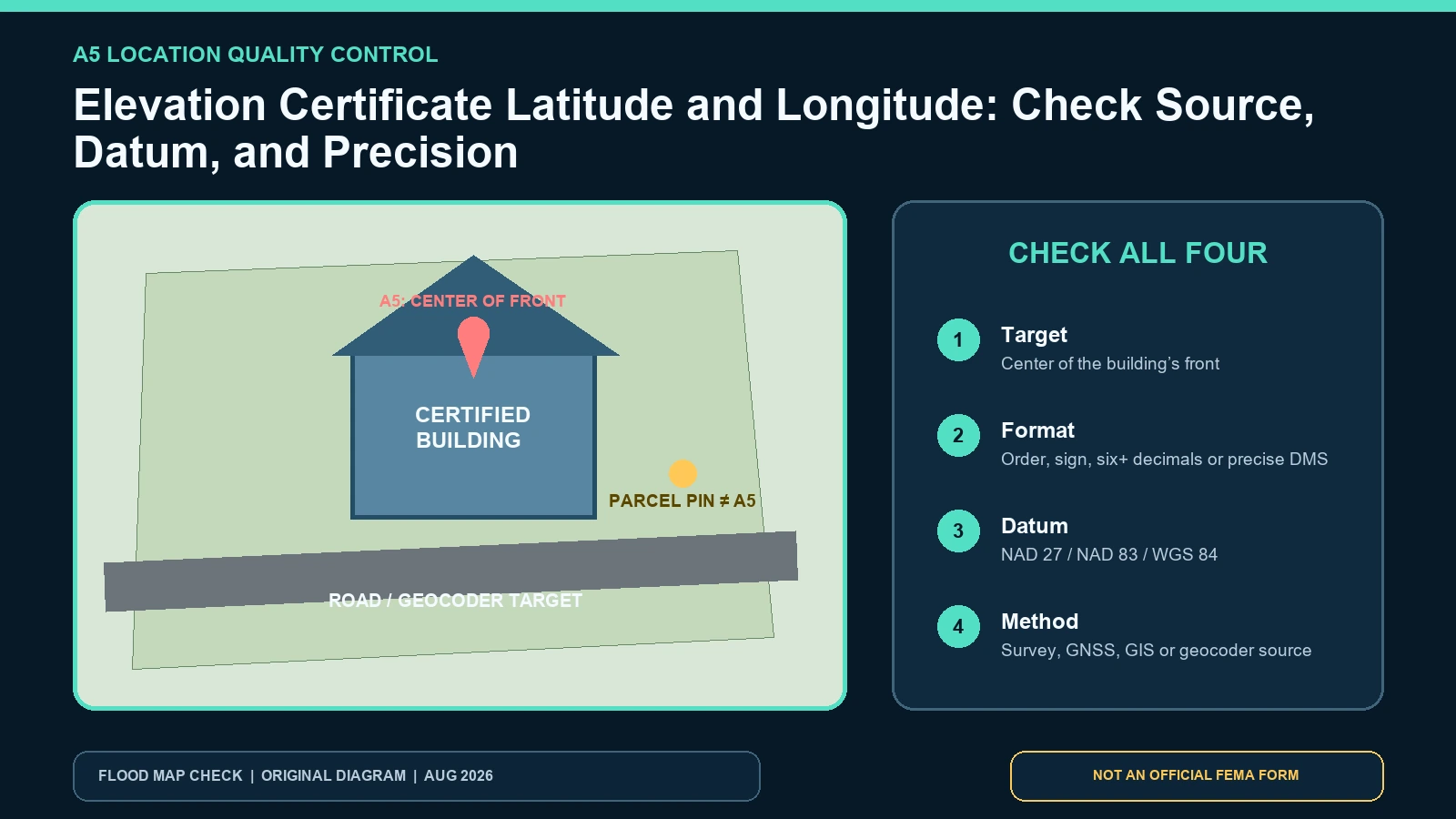
Elevation Certificate coordinates should locate the center of the front of the building-not merely the parcel, driveway, mailing address, or map panel. FEMA’s Item A5 instructions allow decimal degrees or degrees-minutes-seconds, require stated precision, and require the horizontal datum. FEMA prefers NAD 1983 and asks the preparer to describe the method or source in comments. Section D separately records whether a licensed land surveyor provided the coordinates.
Last checked: August 7, 2026.
Use latitude and longitude as an identity check, not as an elevation measurement or boundary survey. A coordinate can be numerically well formatted yet point to the wrong building on a large parcel. It can also describe the right building in a different horizontal datum or with too little precision to distinguish nearby structures. Audit four things together: location target, numeric format, horizontal datum, and acquisition method.
Put the point on the building, not somewhere convenient
Open current aerial or parcel context and plot the A5 coordinate. The point should fall at the center of the front of the certified building under the current instructions. Identify the front consistently with the photo packet and building access-not simply the north side. On corner lots, campuses, condominium sites, mobile-home parks, farms, and properties with detached structures, save a sketch showing which facade and structure the point represents.
A geocoder commonly returns a road centerline, parcel centroid, rooftop estimate, or address interpolation. Those may be useful for finding the property but do not necessarily meet A5’s building-front target. If the plotted point falls at the road, lot center, neighbor, detached garage, or another unit, do not nudge the number until it looks right. Return to the stated source or qualified preparer and obtain a documented correction.
| Plotted point lands on | Likely interpretation | Evidence needed | Action |
|---|---|---|---|
| Center of the building’s front | Consistent with the current A5 target | Photo orientation, structure ID, datum and method | Retain the QA screenshot and source note |
| Parcel center but away from building | Parcel centroid or generalized GIS point | Parcel boundary, building footprint and source metadata | Request building-specific coordinates |
| Road or driveway | Address interpolation or navigation point | Geocoder/source description | Do not use as A5 without correction |
| Detached garage or neighboring structure | Wrong feature selected | Site plan and separate building identifiers | Correct the structure match before any map conclusion |
| Near building but offset consistently | Possible datum, precision or basemap alignment issue | Datum transformation, coordinate digits and imagery date | Investigate source; do not assume which layer is wrong |
Keep latitude and longitude in the correct order and sign
In the United States, latitude is usually positive north of the equator and longitude negative west of Greenwich when written as signed decimal degrees. A missing minus sign can move a U.S. longitude across the world. Reversed latitude and longitude may fail completely or map to an unrelated location. Preserve hemisphere letters or signs exactly and do not add both a negative sign and a west suffix in a system that interprets both, because some software can reverse the meaning twice.
FEMA’s instructions give decimal-degree examples and require at least six decimal places or better; for degrees-minutes-seconds they require seconds to at least two decimal places or better. More digits are not proof of survey accuracy. They show numeric resolution. Record the original format, avoid repeatedly converting between formats, and compare the plotted result after any conversion. A rounded copy in an email should not replace the value retained in the signed certificate.
Horizontal datum and vertical datum answer different questions
A5’s horizontal datum defines the latitude/longitude reference. The form offers NAD 1927, NAD 1983, and WGS 84. C2 and B11 use vertical datums for elevation, such as NAVD 88 or NGVD 29. Do not copy NAVD 88 into A5 or use NAD 83 as the vertical datum. A certificate can correctly use NAD 83 for horizontal position and NAVD 88 for elevations because the two fields describe different dimensions.
A horizontal-datum mismatch can shift the plotted point even when the coordinate digits are unchanged. The effect may be subtle on a large rural parcel or decisive for adjacent townhouses. Record the datum with the number and use mapping software that interprets it explicitly. Web maps commonly display WGS 84-like coordinates, but that does not authorize relabeling an NAD 27 value. Ask the provider to transform the coordinate and document the operation.
Record the method so precision claims remain honest
The comments should identify whether coordinates came from a licensed survey, GNSS observation, real-time network, official GIS building footprint, geocoder, or another source. Section D asks whether a licensed land surveyor provided them. That checkbox is evidence about the source, not a universal accuracy grade. Weather, canopy, urban canyon, antenna setup, correction service, observation time, and post-processing can affect GNSS results; imagery and parcel layers have their own dates and offsets.
If a professional survey provided A5, preserve the field report or project note that ties the point to the building. If an owner or official used an online source, record the source URL, retrieval date, layer name, feature selected, and coordinate reference metadata. A claim such as “GPS coordinates” without device, method, datum, or target is not reproducible.
| Official record | Use it to verify | Record this evidence | What it cannot decide |
|---|---|---|---|
| FEMA Item A5 and Section D | Target point, format, precision, horizontal datum, method comment and surveyor checkbox | Original coordinate, format, datum, source and preparer | Parcel boundary or vertical elevation |
| FEMA Map Service Center | Address/coordinate search context and mapped flood products | Search input, selected panel and checked date | A certified building coordinate |
| FEMA MSC search training | MSC search accepts address, place, or longitude-latitude in decimal format | Input order, result community and panel | Whether A5 was measured correctly |
| Local parcel/building GIS or survey record | Independent building-footprint and parcel context | Layer owner, date, feature ID and CRS | A FEMA or boundary determination unless the agency says so |
Run a reproducible coordinate quality check
- Copy A5 exactly, including sign or hemisphere, decimal places and horizontal datum.
- Identify the coordinate method and whether Section D says a licensed surveyor supplied it.
- Plot the point in software that recognizes the stated datum; do not silently assume WGS 84.
- Compare the result with the same building shown in A2/A3, the site sketch and the labeled photo views.
- Record distance and direction only as a QA observation, not as an owner-made corrected coordinate.
- Check imagery, footprint and parcel layer dates before declaring a mismatch.
- Route unresolved or material errors to the preparer, local official and receiving party.
| QA field | Recorded value | Pass question | Escalation trigger |
|---|---|---|---|
| Structure | Address + parcel + building ID | Is one exact structure identified across form and photos? | Multiple buildings or conflicting identifiers |
| Coordinate | Unrounded latitude and longitude | Do signs/order plot in the expected region? | Wrong state, road point or neighboring building |
| Horizontal datum | NAD 27, NAD 83, WGS 84 or stated other | Was the same datum used by the plotting step? | Blank, assumed or relabeled datum |
| Method | Survey/GNSS/GIS/geocoder plus source | Can another reviewer repeat the acquisition? | Only “GPS” or “online map” stated |
| Precision | Decimal places or DMS seconds | Meets form formatting while reflecting source honestly? | Rounded value cannot distinguish structures |
| Map comparison | Basemap/layer owner and date | Are apparent offsets explainable by data age or alignment? | Material mismatch remains after source review |
Save a small QA image showing the building footprint, plotted point, north arrow, layer name, and checked date. Do not publish private owner names or a precise coordinate when public disclosure would create a security or privacy problem; the certificate’s authorized recipients can receive the full record. The operational goal is to prevent a wrong-structure match, not to create a public property tracker.
Failures that produce a convincing but wrong point
The most common failure is using an address search result as if it were a measured building point. Others include reversed coordinate order, a dropped western-hemisphere sign, converting DMS incorrectly, trimming digits before plotting, assuming every web map uses the listed datum, and matching a parcel pin to the nearest structure. Another subtle failure is judging an older coordinate against newer imagery after the building was demolished or replaced.
Do not “average” two conflicting coordinates. Find which target, datum, method, and date each represents. One may locate the parcel; the other may locate the front of the building. If both claim to be A5 for the same structure and the difference is material, ask the certifier to resolve it and issue an authorized correction if needed.
Use the Elevation Certificate source guide when obtaining the complete record and comments. If the point selects the wrong map panel, repeat the current official search with the FIRM/FIS BFE workflow but do not edit A5 yourself.
What A5 coordinates do not prove
A5 does not establish a legal parcel boundary, setback, easement, ownership, flood-zone line, BFE, ground elevation, or lowest-floor elevation. It is not a location certificate for construction staking. A coordinate inside a Special Flood Hazard Area display does not replace the effective panel, local interpretation, survey, or lender determination. Conversely, a point outside a shaded polygon does not guarantee the building is outside every flood hazard or will not flood.
Review a lender’s mapped decision through the Standard Flood Hazard Determination guide. That record may use parcel or structure evidence under a separate process. Keep this page’s decision limited to whether A5 identifies the intended building with a stated, reproducible horizontal reference.
Questions about coordinates on the certificate
Can I use coordinates copied from a phone map?
They may help screen the location, but document the source, target and datum and confirm the point meets FEMA’s building-front instruction. Do not present consumer-map precision as a survey.
Why does the point look offset on aerial imagery?
Possible causes include wrong target, datum mismatch, rounding, geocoder interpolation, or basemap/imagery alignment and age. Compare metadata before assigning fault.
Are A5 coordinates the same as the benchmark in C2?
No. A5 describes horizontal building location. The C2 benchmark and vertical datum establish the elevation reference. They must be audited separately.
The coordinate should answer one identity question
Confirm that A5 plots at the center of the front of the exact building, retain the original precision and sign, honor the stated horizontal datum, and record the acquisition method. Treat a discrepancy as a source problem to resolve, not a number to drag on a map. FEMA form and MSC references were checked August 7, 2026; verify the latest posted instructions before a new certificate is completed.