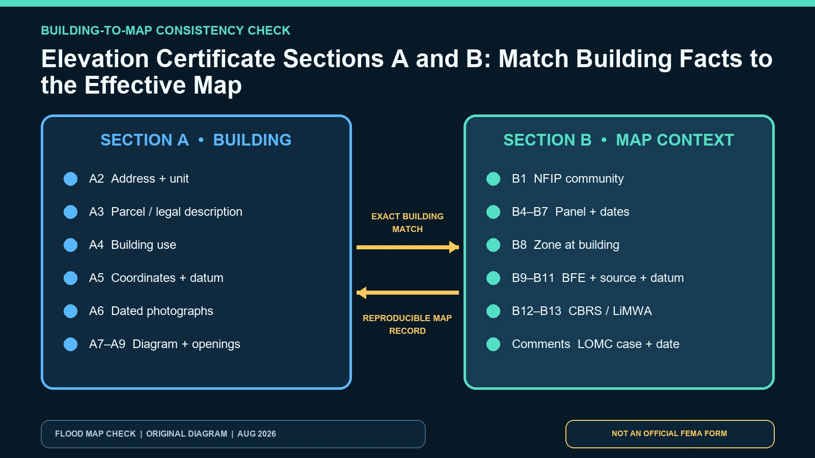
Audit Sections A and B as one identity chain: the exact building in Section A must be located in the community, panel, zone, and BFE context recorded in Section B. Match the street address and unit, legal or parcel description, building use, coordinates, photos, and Building Diagram with the effective FIRM and Flood Insurance Study. FEMA’s Elevation Certificate instructions say Section B should use the FIS and FIRM in effect at certification and explain how to record annexations, map changes, and Letters of Map Change.
Last checked: August 7, 2026.
Do not approve the certificate because every blank contains text. A polished form can join Building A’s photographs to Building B’s parcel, an old community number to a current jurisdiction, or the correct panel to the wrong flood zone. Retrieve official map products from the FEMA Map Service Center, preserve the dates, and make every cross-record match explicit before anyone relies on later elevation sections.
Build one unambiguous structure identity in Section A
A1 through A4 identify the owner, building address, property description or parcel, and use. The certificate concerns a building, not an owner or parcel in the abstract. On properties with multiple structures, include a description that distinguishes the certified building. A mailing address can cover several units or buildings; a tax parcel can remain constant after demolition and reconstruction. Match permanent features, site plan, coordinates and photographs rather than one identifier alone.
The building-use description affects interpretation. Residential, non-residential, addition, accessory structure, manufactured home and mixed-use conditions should not be collapsed into “property.” If the certificate covers an addition, say which part and how it connects to the main building. If an owner name changed after a sale, that can be a historic fact rather than proof the structure identity is wrong. Record certification-time and current ownership separately.
| Section A field | Cross-check source | Expected match | Mismatch action |
|---|---|---|---|
| A1 owner | Deed/authorized property record at relevant date | Explains who owned the building when prepared | Do not reject solely for later sale; document date context |
| A2 address | Local address record, site and photo page | Same building/unit number, city, state and ZIP | Resolve aliases, renumbering and wrong unit before map search |
| A3 description/parcel | Recorded plat, assessor or legal description | Parcel and structure descriptor point to the same site | Separate parcel change from building change |
| A4 use | Permit, occupancy or actual documented use | Specific building use at certification | Ask local official when mixed or changed use affects compliance |
| A5 coordinates | Plotted point, datum and method | Center of front of the identified building | Route wrong-structure or datum issue for correction |
| A6/A7 | Dated photos, plans and visible foundation | Photos and diagram describe the same building form | Recheck diagram and fields A8/A9/C2 |
| A8/A9 | Field observation and engineered-opening records | Enclosures/garage and openings belong to this structure | Do not import counts from another building or detached garage |
Find the community that regulates the building now
B1 records the NFIP community name and six-digit identification number. This may not be identical to the postal city or county. Unincorporated areas, incorporated cities, tribal jurisdictions, annexations and community dissolutions can change which local government administers the site. Confirm the building coordinates or parcel against the current jurisdiction and ask the local floodplain administrator when boundaries are unclear.
FEMA’s instructions address a building mapped in one community but now located in another because of annexation or dissolution. They tell preparers to enter the community where the building is now located in B1 and the current county where needed, while using information from the actual FIRM panel showing the building in B4, B5, B7, B8 and B9-even if that panel was issued for the previous jurisdiction. Explain this split in comments rather than forcing every label to come from one source.
Read the panel number, suffix, index date, and panel date separately
B4 and B5 identify the map/panel number and suffix. B6 is the FIRM Index Date; B7 is the effective or revised date of the panel that includes the building. These dates can differ. A common error copies the panel date into both boxes or uses a countywide index date from another map series. Save a current Map Service Center result and the panel title block so a reviewer can reproduce each value.
FEMA’s official Map Service Center training explains that Search by Address finds the current effective map and panel information, while Show All Products exposes FIS reports, historical and preliminary products, and Letters of Map Change. The static original panel may need to be read together with revisions, amendments and revalidations. Preliminary products are not the effective FIRM merely because their publication date is newer.
Tie B8 through B11 to the building point and official source
B8 records the flood zone or zones at the building, not every zone on the parcel or panel. B9 records the Base Flood Elevation or, in Zone AO, base flood depth. B10 names the source-FIRM, FIS, community-determined or other-and B11 states the elevation datum. The value, source and datum must travel as a set. A BFE without a source or datum cannot safely be compared with surveyed C2 elevations.
When a zone boundary crosses a large building or several zones are relevant, document how the point and footprint were evaluated and ask the local official for the accepted treatment. Do not estimate the BFE from map shading. Use the FIS profile, FIRM, regulatory data or documented community determination appropriate to the site. In Zone AO, preserve depth and reference to highest adjacent grade rather than converting it into an unsupported absolute BFE.
| Section B field | Official evidence | Consistency test | What to save |
|---|---|---|---|
| B1-B3 | NFIP community/jurisdiction record | Current regulating community contains the building | Community name/ID, county, state and boundary evidence |
| B4-B5 | FIRM panel title block/MSC result | Panel footprint contains the structure point | Full panel number and suffix |
| B6 | Applicable FIRM index | Index belongs to the same map series/community | Index date and source file |
| B7 | Effective/revised panel | Date belongs to B4/B5 panel | Panel effective date and checked date |
| B8 | Effective FIRM/NFHL plus official interpretation | Zone is read at the identified building | Zone(s), location evidence and boundary caveat |
| B9-B11 | FIRM/FIS/community source | BFE/depth, source and datum agree | Value, source page/profile, datum and units |
| B12-B13 | CBRS/OPA and LiMWA official map evidence | Answers refer to the structure location | Designation or limit source and date |
Treat Letters of Map Change as linked evidence, not a new colored layer
A Letter of Map Amendment, Letter of Map Revision Based on Fill, or Letter of Map Revision can affect how the effective map applies to a structure or parcel. FEMA’s instructions call for the letter date and case number in comments when one has been issued. Retrieve the actual letter and exhibits. Match the case to the same structure or legally described land; similar address text or proximity is not enough.
A LOMC can coexist with the original panel because it amends or revises the effective record. Do not erase B4/B7 and replace them with the letter date. Preserve the panel information and document the case separately. If construction or fill conditions required by the case have changed, or a later map supersedes the context, ask the community and FEMA Map Specialist what evidence controls the current decision.
| Official record | Use it to verify | Record this evidence | What it cannot decide |
|---|---|---|---|
| FEMA Sections A/B instructions | Who may complete A/B and how fields, annexation and LOMCs are recorded | Form edition, field values, comments and preparer | Whether a local office accepts the final packet |
| FEMA Map Service Center | Effective panel, FIS, map dates and map-change records | Search result, product IDs, panel, dates and LOMC | Exact building identity without A evidence |
| FEMA MSC training | Difference between current address search, Show All Products and historic/preliminary records | Search method, product class and effective status | A survey or local permit decision |
| Local floodplain administrator | Community boundary, local BFE, ordinance and map interpretation | Contact, date, evidence supplied and written response | FEMA map revision or insurer decision |
Complete a field-to-source worksheet before reviewing C2
- Lock one building with address, parcel/legal description, coordinates, use, site sketch and labeled photos.
- Confirm the NFIP community and county that regulate the structure today, noting annexation history.
- Retrieve the effective panel and FIS; record B4-B11 from their distinct source locations.
- Search revisions, amendments, revalidations and LOMCs and match every case to the same building or land.
- Compare the Section B datum with the C2 datum before any elevation subtraction.
- Write unresolved conflicts in comments or a review memo; do not silently harmonize values.
- Have the preparer, qualified certifier and local official address fields within their authority.
The A5 coordinate audit helps resolve wrong-structure points. The FIRM and FIS BFE guide shows how B9-B11 travel together. Keep the full source trail with the certificate using the official EC source workflow.
Stop when identifiers agree only superficially
Stop if the address matches but the photos, coordinates or parcel describe another structure. Stop if B1 uses the mailing city while the property is regulated by a different NFIP community. Stop if B4 is correct but B7 belongs to another suffix, if B8 was read from a preliminary layer, or if B9 was copied without B10/B11. Stop if a map-change letter names another structure or only a portion of the parcel.
Another failure is updating one field to current conditions while leaving the rest historic. For example, inserting a current zone into an old signed certificate without updating the panel date and source creates an internally inconsistent record. Preserve the historic certificate and add an authorized current-map supplement or replacement as the recipient requires.
What a clean A/B match does not prove
Accurate Sections A and B do not validate the surveyed elevations in C2, verify construction quality, establish local code compliance, set a premium, waive flood insurance, decide a claim, establish title or boundary, or guarantee that the building will not flood. They establish that the certificate’s building identity and official map context are coherent enough for the next reviewer to use the remaining evidence.
A lender’s Standard Flood Hazard Determination is a separate record. Compare it through the SFHDF guide when the community, panel or zone differs, but do not overwrite the EC based on a consumer-facing determination notice. Resolve the source and date behind each document.
Questions that surface during an A/B audit
Which community name goes in B1 after annexation?
FEMA’s instructions say to use the community where the building is now located, while certain panel fields may still come from the actual panel issued for the prior jurisdiction. Explain the split and confirm it locally.
Is the FIRM Index Date the same as the panel effective date?
Not necessarily. B6 and B7 are separate fields tied to different source elements. Retrieve the applicable index and panel rather than copying one date twice.
Can a parcel have several zones?
Yes, but B8 concerns the building location. Where a boundary intersects the building or the situation is unclear, document the footprint and obtain official interpretation.
One building, one reproducible map context
A sound Sections A/B audit lets another reviewer start with the same structure, reach the same community and panel, retrieve the same effective FIRM/FIS and LOMC record, and understand the BFE source and datum. It does not force historic and current facts into one edited form. FEMA form and MSC sources were checked August 7, 2026; repeat the lookup whenever ownership, address, jurisdiction, map panel or effective map changes.