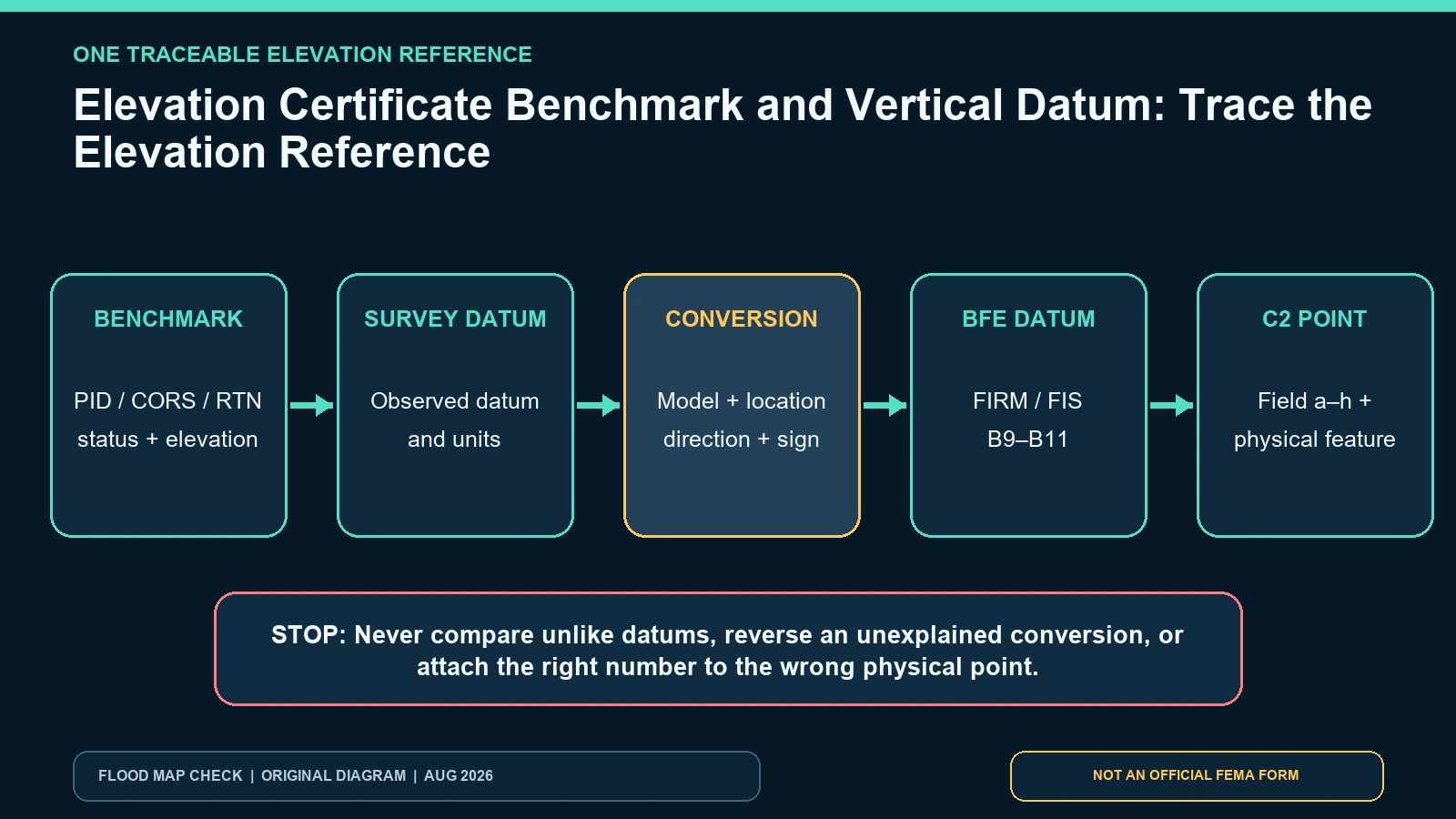
Before comparing any Elevation Certificate value with a Base Flood Elevation, confirm that both numbers use the same vertical datum. Section C2 of FEMA’s current posted Elevation Certificate asks for the benchmark utilized, its vertical datum, and whether a conversion factor was used. The instructions require a unique benchmark identifier when available and say all C2 elevations must use the datum on which the BFE is based. When field-survey and BFE datums differ, the conversion and software source belong in Section D comments.
Last checked: August 7, 2026.
A benchmark name is not decoration. It is the first link in the evidence chain that lets another surveyor or reviewer reproduce the elevation reference. A certificate that lists feet but omits or confuses NAVD 88, NGVD 29, a local tidal datum, or a project datum can produce a plausible-looking comparison that is wrong by a meaningful amount. Do not add or subtract elevations until the benchmark, datum, units, and conversion direction have been resolved by a qualified person.
Trace five links instead of comparing two numbers
A defensible elevation comparison has at least five linked records: the monument or positioning reference used for the survey; the published or computed elevation assigned to it; the vertical datum of that elevation; any conversion used to reach the FIRM or FIS datum; and the physical point reported in C2. Write the chain in that order. If any link is missing, report the comparison as unresolved rather than filling the gap from a generic online converter.
The label “benchmark utilized” may contain an NGS Permanent Identifier, a local agency monument number, a project control point, a Continuously Operating Reference Station used for an OPUS solution, or a real-time network name. FEMA’s instructions specifically tell the preparer to provide the PID or another unique identifier assigned by the benchmark maintainer. For GPS work they call for the base-station benchmark, CORS sites and attached OPUS report, or real-time network name. A handwritten description such as “county benchmark” is not enough to retrieve the source.
| Trace element | Acceptable evidence | Mismatch signal | Resolution owner |
|---|---|---|---|
| Benchmark identity | PID, agency monument ID, CORS/OPUS record, or RTN name | Name cannot be found or points to another monument | Surveyor and benchmark maintainer |
| Published elevation | Datasheet or control record with value, unit, datum and observation/status date | Value copied without date or datum | Surveyor and official control source |
| Survey datum | Datum stated for field observations and C2 | “Mean sea level” or blank datum | Certifying professional |
| BFE datum | Section B11 plus FIRM/FIS source | BFE datum differs from C2 datum | Local official and surveyor |
| Conversion | Named tool/model, location, direction, factor and calculation in comments | Unexplained constant or reversed sign | Qualified professional |
| C2 physical point | Field label, building diagram and measured feature | Correct datum attached to the wrong floor or grade point | Surveyor, designer and local reviewer |
Read NAVD 88 and NGVD 29 as coordinate systems, not labels for sea level
The National Geodetic Survey vertical-datum page defines a vertical datum as the zero-elevation reference surface for heights. It identifies NAVD 88 as the current national vertical datum for the contiguous United States and Alaska and NGVD 29 as superseded historical datum. Those facts do not supply a nationwide fixed offset between them. The difference varies by geographic position, so a conversion borrowed from another county or project can be wrong.
NGS’s VERTCON sign-convention guidance explains that its modeled shift is NAVD 88 minus NGVD 29 at the specified position. To convert an NGVD 29 height to NAVD 88, its example adds that signed model value; the reverse conversion subtracts it. This is a useful audit of direction, not permission for an owner to modify certified elevations. Record the coordinates, model or software version, input and output datums, signed factor, units, and who performed the conversion.
Use the effective FIRM and FIS to identify the BFE datum
Open the property’s current products in the FEMA Map Service Center. Section B of the form obtains the BFE and datum from the effective FIRM and Flood Insurance Study or another identified official source. Save the panel, suffix, effective date, BFE source, BFE value, and B11 datum. If a Letter of Map Change affects the site, record the case and letter date. A current web layer without the panel and source record is not a complete datum reference.
Some certificates correctly preserve a historic map context because they were prepared under an earlier effective FIRM. That does not authorize a direct comparison with today’s BFE. Build a two-column history: map/BFE/datum at certification and map/BFE/datum for the current decision. If the map changed but the building did not, the old surveyed elevations may remain usable, yet they still must be expressed in or converted to the datum of the BFE used in the new comparison.
| Official record | Use it to verify | Record this evidence | What it cannot decide |
|---|---|---|---|
| FEMA EC form and instructions | Required benchmark identifier, C2 datum, same-datum rule and conversion comments | PID/RTN/OPUS, datum, conversion source, C2 values | Whether a control point is stable today |
| FEMA Map Service Center | Effective FIRM/FIS, BFE source and map history | Panel, date, BFE, B11 datum and LOMC | The survey’s field datum or conversion quality |
| NGS vertical datums | Official datum definitions and status | Datum name, region and source date | A property-specific shift |
| NGS VERTCON method | Modeled NAVD 88/NGVD 29 shift direction at a position | Coordinates, signed value, direction and units | A replacement for professional survey judgment |
Audit the arithmetic without recertifying it
A reviewer can check whether the chain is internally coherent. Confirm all values use feet, except the form’s Puerto Rico meter provision where applicable. Verify that a conversion factor carries a sign and that the stated direction matches the calculation. Check whether rounding occurred only after conversion; FEMA instructs C2 entries to the nearest tenth. Compare the reported benchmark value with the cited datasheet and make sure the measured physical point has not been confused with the benchmark elevation itself.
| Audit line | Value to record | Control question | Stop condition |
|---|---|---|---|
| Field reference | Benchmark ID and published elevation | Can another reviewer retrieve the same record? | Identifier missing, destroyed mark, or value cannot be reproduced |
| Datum pair | Survey datum -> BFE datum | Are the source and target stated explicitly? | One datum blank or described only as sea level |
| Conversion | Signed factor, software/model and coordinate | Does direction reproduce the reported converted value? | Factor copied from another location or sign unexplained |
| Rounding | Unrounded working value and final tenth | Was the calculation completed before rounding? | Intermediate rounding changes the result |
| C2 destination | a-h field and physical feature | Is this the floor, member, slab, equipment, grade, deck or stair point intended? | Number is assigned to the wrong building reference |
Do not publish a numeric conversion example as though it applies to every property. If an article or spreadsheet illustrates the workflow, label all values hypothetical and omit a result until a location-specific official model is run. For an actual certificate, the conversion belongs to the professional record and Section D comments.
Recognize unstable or unsuitable control
Benchmarks can be superseded, disturbed, destroyed, reset, or affected by subsidence. FEMA’s instructions warn that in areas experiencing subsidence, the most recent reference-mark elevations must be used for building elevations while the BFE itself should not be adjusted. Review the benchmark datasheet’s status, recovery notes and dates. A monument that still exists physically may no longer carry the elevation printed in an old project notebook.
GPS-derived orthometric heights add another dependency: coordinate reference, ellipsoid height, geoid model, base station or network, and processing report. NGS explains that deriving NAVD 88 orthometric height from GNSS requires the geometric reference and geoid height. A phone GPS elevation is not a substitute. If the OPUS report or RTN description cited by the survey is missing, ask the certifier for the supporting record rather than reverse-engineering it from rounded C2 values.
The separate BFE lookup guide helps identify the FEMA source; it does not perform the survey conversion. The Elevation Certificate source guide helps preserve the correct form and attachments when requesting clarification from the certifier.
Failures that invalidate a direct comparison
- C2 is NAVD 88 while B9/B11 is NGVD 29, with no conversion source or calculation in comments.
- A benchmark name has no unique identifier and cannot be found in the cited control network.
- A VERTCON or other offset was copied from a different coordinate, or its sign was reversed.
- An ellipsoid height from GPS was reported as though it were a NAVD 88 orthometric elevation.
- Feet and meters, or tenths and hundredths, were mixed during transcription.
- The datum is correct but the number describes the wrong C2 physical point or another building.
- A historic benchmark value is used in a documented subsidence area without reviewing current control.
Each failure should produce a targeted request: provide the PID and datasheet; identify the BFE datum; attach the OPUS report; name the conversion model; show the signed calculation; or remeasure the physical point. Avoid the vague instruction “fix the elevations,” which hides the broken link and makes later review harder.
What a clean datum trace does not prove
A consistent benchmark and datum chain does not prove that the correct building diagram was selected, the physical points were measured correctly, the structure complies with local freeboard requirements, or an insurer will use a particular elevation for rating. It does not establish a flood zone or change a FIRM. It proves only that the elevation numbers can be compared within a stated reference framework.
Do not use the lender’s flood hazard determination as a benchmark source. That form concerns mapped hazard and insurance requirements, not field control. Keep the technical question narrow: can every C2 number be traced through one documented datum path to the BFE used in the decision?
Questions reviewers ask about the elevation reference
Can I subtract a NAVD 88 number from an NGVD 29 BFE?
Not directly. A location-specific, documented conversion must put the values on the same datum. The qualified professional should record the source, direction, factor, and resulting value.
Is the benchmark elevation the same as C2.a?
No. The benchmark is the control reference used to establish surveyed elevations. C2.a is the measured top of the bottom floor identified by the selected building diagram.
Does NAVD 88 always mean the survey is current?
No. The datum name alone says nothing about benchmark status, observation date, subsidence, method, or whether the right physical point was measured.
Close the evidence chain before comparing elevations
Record the benchmark’s unique ID and current source, survey datum, BFE datum, conversion method and sign, units, rounding, and destination C2 field. If any element is missing or conflicting, send a field-specific question to the certifier and local official. Do not compute an owner-made correction. Official source scope was checked August 7, 2026; reopen FEMA and NGS records whenever the benchmark, map, datum guidance, or certificate changes.