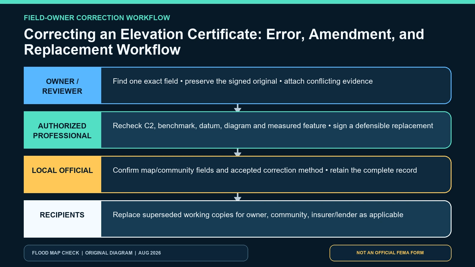
Do not erase, annotate, or overwrite a signed Elevation Certificate when you discover an error. Preserve the complete original, identify the exact field and supporting evidence, and route the problem to the person authorized to correct that part of the record. A wrong surveyed value in Section C normally needs the certifying professional’s work and may require a replacement certificate. Property or map information in Sections A or B may involve the owner, original preparer, or local floodplain official, but the receiving community or insurer should state what corrected package it will accept.
Last checked: August 7, 2026.
Begin with the instructions inside FEMA’s Elevation Certificate form. They distinguish property information, FIRM information, surveyed elevations, professional certification, community information, and attachments. FEMA’s live underwriting forms page is the safest place to obtain the currently posted file. A correction is reliable only when it preserves who supplied each fact, who certified it, and which version supersedes the erroneous copy.
Name the error before asking anyone to fix it
Write the field label, the value shown, the value believed correct, and the evidence for that belief. “The certificate is wrong” is not actionable. “A2 identifies Building B, but the photographs and parcel sketch show Building A” is. So is “C2.e lists the lowest machinery platform at 12.4 feet, while the survey notes identify the same point as 10.4 feet.” Avoid deciding that a value is wrong merely because it differs from a real-estate listing, consumer map, or another certificate prepared for a neighboring structure.
Separate transcription issues from professional measurements and changed conditions. A misspelled owner name is not the same as a wrong vertical datum. A correct 2019 grade elevation can differ from today’s grade because the site was regraded. A map panel can be superseded after certification without making the original Section B false for its certification date. Each situation produces a different record: clarification, correction, current-map supplement, or new survey.
| Error class | Examples | Who must be involved | Expected record |
|---|---|---|---|
| Building identity | Wrong unit, building number, parcel, use, or structure on a multi-building lot | Original preparer and local official; surveyor if location evidence is certified | Corrected form or documented replacement tied to the exact structure |
| Map context | Panel, suffix, effective date, zone, BFE source, datum, unlisted LOMC | Local floodplain official and preparer; FEMA MSC evidence | Authorized correction, Section G action where lawful, or attached memo/current-map record |
| Building diagram or openings | Wrong A7, enclosure area, vent count or rated area | Certifier/preparer and local official | Field-verified corrected or replacement EC with required opening documentation |
| Surveyed elevation | C2 value, benchmark, datum conversion, grade or M&E point | Professional authorized by state law to certify elevation information | New or corrected signed and sealed professional record |
| Changed condition | Addition, regrading, moved equipment, completed construction | Local official plus qualified professional | New finished-condition evidence rather than alteration of the historic original |
Preserve the original and create a correction log
Save the PDF exactly as received and calculate or record a file hash if the transaction is sensitive. Keep all pages, photographs, calculations, sketches, seals, and comments together. In a separate log, record the discovery date, field, suspected error, source of the challenge, people contacted, response, and disposition. Mark working copies “review copy” without placing notes over the certified values. The goal is a traceable chain, not a cleaner-looking PDF.
If several parties already possess the erroneous file, list them before the correction is issued: owner, community permit file, insurance agent or company, lender, buyer, engineer, and closing professional. FEMA’s form directs that all pages and attachments be copied for the community official, insurance agent or company, and building owner. A correction that reaches only one party leaves conflicting records in circulation.
Route surveyed fields back to an authorized professional
Section C states that a field survey is required for C2.a through C2.h, and Section D is the certification of the surveyor, engineer, or architect authorized under state law. An owner, website, lender, or insurance agent cannot recalculate a C2 value and preserve the professional certification. Send the original certificate, field notes if available, the exact challenged field, and objective conflicting evidence to the original certifier. If that person is unavailable, ask the local official what a new qualified professional must observe and document.
Do not ask a second professional merely to copy a preferred number. The professional needs enough evidence to identify the building diagram, physical reference point, benchmark, vertical datum, conversion, units, construction status, and present condition. Concealed crawlspace floors, inaccessible equipment, removed benchmark marks, and undocumented grading can prevent a defensible correction. That outcome is a request for new evidence, not permission to estimate.
Handle Sections A and B without breaking the certification chain
FEMA’s instructions allow a property owner, authorized representative, or local floodplain official to complete Sections A and B, after which the professional should verify the information for completeness. Use the Map Service Center for the FIRM, FIS, effective date, and map-change evidence. If a LOMA, LOMR-F, or LOMR exists, the form instructions call for the letter date and case number in the appropriate comments area.
Authority varies by field and state law. A local official may be able to document corrected non-survey information through an authorized community process, a separate memo, or Section G; another jurisdiction may return the entire form to the original preparer. Ask before marking the form. Never place another person’s initials, seal, or digital signature on an edited file, and never detach a corrective memo when distributing the certificate it qualifies.
| Official record | Use it to verify | Record this evidence | What it cannot decide |
|---|---|---|---|
| FEMA form and field instructions | Who may complete each section and what C2/D certification covers | Field label, form edition, comments and attachments | Whether a state permits a specific correction method |
| FEMA Map Service Center | Effective FIRM/FIS and LOMC evidence for a challenged Section B entry | Panel, suffix, dates, zone, BFE source and case | A corrected surveyed elevation |
| FEMA EC FAQ | Whether changed physical conditions call for a new certificate | Scenario and affected sections | Who is professionally liable for a correction |
| Local floodplain administrator | Accepted local correction, permit-file and Section G procedure | Written direction, reviewer and distribution list | A private insurer’s final underwriting action |
Build one replacement packet and retire conflicting copies
A replacement packet should state which prior certificate it supersedes, but it should not destroy the prior record. Use a clear file name with property identifier, certification date, and revision date. Include the new complete form, all attachments, photographs, professional comments, and any local memo. If only a map-context supplement is issued, keep it visibly attached to the historic certificate and identify the exact fields it updates for the present use.
- Obtain written correction instructions from the community or receiving party before anyone edits a record.
- Return survey-derived and professionally certified fields to an authorized professional.
- Verify that the new packet names the same building and carries every page, attachment, signature, date, and seal required.
- Compare old and new values field by field; unexplained changes require another review.
- Send the corrected packet to every known holder and ask them to retire the superseded working copy.
- Keep a read-only archive of the original, correction request, evidence, responses, and final distribution.
If the dispute is really about where the original should be sent or obtained, use the Elevation Certificate source guide. If it concerns the BFE rather than the building survey, first compare the FIRM and FIS BFE sources so the certifier receives the controlling map evidence.
Common correction failures
One failure is editing a fillable PDF after it was signed, leaving the signature image while changing a certified number. Another is asking the insurer to fix a surveyor’s elevation. A third is accepting a new C2 value without a building diagram, benchmark, datum, or explanation of the measured point. A fourth is correcting an owner name while missing that the photographs show another structure. A fifth is distributing only the changed page, which separates it from comments and attachments needed to interpret it.
Conflicting certificates need reconciliation, not automatic selection of the newest or lowest number. Compare structure identity, construction stage, certifier, method, benchmark, vertical datum, measurement point, and map date. A newer certificate may reflect actual construction or regrading; it may also contain a transcription error. Ask the professionals and local official to resolve the conflict in writing.
What a correction cannot accomplish
A corrected Elevation Certificate does not change the effective FIRM, issue a Letter of Map Change, guarantee code compliance, set an insurance premium, waive a lender’s flood requirement, establish a property boundary, or prove that a building will not flood. It records corrected facts within its scope. The receiving agency, community, insurer, lender, or map-change process makes its own decision using that record and other evidence.
A lender’s separate determination should be reviewed through the Standard Flood Hazard Determination workflow. Do not force an EC correction when the alleged conflict comes from a different form answering a different regulatory question.
Questions that arise after an error is found
Can the owner fix a typo in Section A?
The owner may be an authorized source for some Section A information, but should not alter a signed certificate. Ask the preparer and local official for the accepted correction method and redistribute the complete corrected packet.
What if the original surveyor is no longer available?
Contact the local floodplain administrator and a professional authorized under state law. The replacement professional must have enough field and source evidence to certify the needed facts independently.
Should the old certificate be deleted?
No. Preserve it as a superseded record with the error report and final correction. The audit trail explains why different versions exist and which one should be used.
The defensible correction path
Keep the original intact, identify one field-level issue at a time, return certified measurements to an authorized professional, use current official map evidence for Section B, and get the local or receiving party’s correction instructions in writing. Then distribute one complete replacement or attached correction record to every holder. Sources and form links were checked August 7, 2026; confirm the currently accepted FEMA edition before the corrected form is signed.