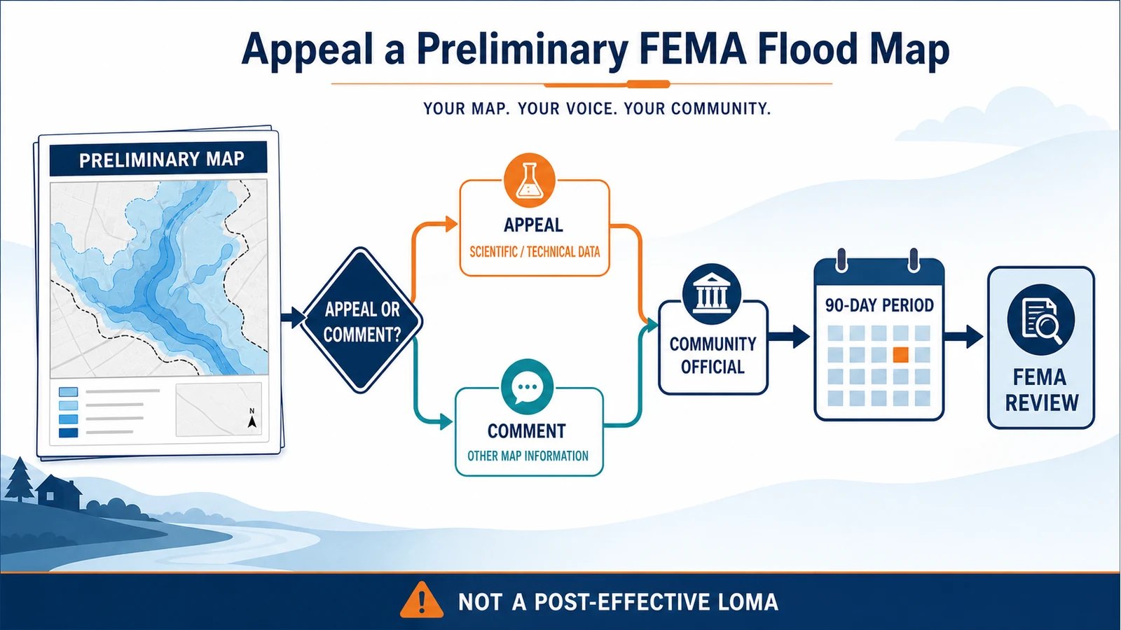
To appeal a preliminary FEMA flood map, send a complete written appeal and its scientific or technical support to your community’s chief executive officer or designated floodplain official during the statutory 90-day appeal period. Do not send the public filing only to FEMA. A formal appeal is for proposed new or modified flood-hazard information that you can show is scientifically or technically incorrect; base-map corrections and other non-appealable issues are comments.
Contact the community official before building the package. The official notice controls the local start date, end date, delivery method, and contact. FEMA’s November 2023 processing guidance says the statutory period cannot be extended, so an incomplete objection near the deadline is a serious risk.
File through your community, not straight to FEMA
The current 44 CFR Part 67 gives an owner or lessee of real property the right to file a written appeal when a proposed flood determination may adversely affect property rights. Sections 67.5 and 67.7 route that filing to the community chief executive officer, or an agency the chief executive publicly designates. FEMA’s information for property owners gives the same practical instruction.
In many places, the working contact will be the floodplain administrator, planning department, public works department, or another official named in the local appeal notice. Ask that office to confirm all of the following in writing: the appeal-period dates, the person or office accepting packages, acceptable file and media formats, any local cover form, and how receipt will be acknowledged.
An appeal and a comment are not interchangeable
Start by naming the exact item you believe is wrong. FEMA classifies the submission by what changed, when the evidence arrived, who submitted it, and whether the supporting data meet Part 67. Calling a letter an appeal does not make it one.
| Issue in the preliminary products | Likely route | What the package needs |
|---|---|---|
| A new or revised Base Flood Elevation, base flood depth, Special Flood Hazard Area boundary, flood-zone designation, or regulatory floodway is scientifically or technically wrong | Formal appeal | Specific error, qualified analysis or measurements, and results showing a more correct flood-hazard determination |
| A road name, road location, corporate boundary, or another base-map feature is wrong | Comment | Current map, GIS record, government record, or other material documenting the correction |
| The concern is outside the revised study area, arrives outside the statutory period, or lacks required technical support | Usually treated as a comment | Submit the best available record, but do not assume it preserves appeal status |
The distinction matters because FEMA’s November 2023 Appeal and Comment Processing guidance says an appeal must concern flood-hazard information introduced or revised by the project and must satisfy the scientific or technical data requirements. A comment can still lead to a correction, but it is not a statutory appeal.
Confirm that the proposed change is actually appealable
Compare the preliminary FIRM and preliminary Flood Insurance Study report with the currently effective versions. Mark the flooding source, panel number, map revision, study table, profile, cross section, and boundary involved. The point is to isolate what the new study changed, not merely to show that a parcel or structure appears inside a shaded area.
The preliminary-versus-effective FEMA map guide explains why both versions must stay in the record. If you need help retaining the panel number, suffix, effective date, scale, and map frame, use the FIRM panel guide. Save the relevant pages of the FIS report as well as the map image; the model inputs, discharge tables, flood profiles, or floodway table may reveal the disputed assumption more clearly than the color on the map.
Part 67 does not turn a personal preference, insurance cost concern, or general statement that a property has never flooded into an appeal. The filing must identify why FEMA’s proposed determination is incorrect and, where required, provide a more correct analysis or measurement.
Use the legal notice to lock the real deadline
Under Part 67, the appeal window is tied to the second publication of FEMA’s proposed determination in a prominent local newspaper. FEMA’s 2023 guidance describes the period as beginning the following day and ending on the 90th day or the first business day thereafter. Use the dates stated by FEMA and the community rather than calculating a deadline from a news story, open-house date, preliminary-map release date, or the day you first heard about the project.
- Save the two newspaper notices or the community notice that identifies their publication dates.
- Record the appeal start and end dates exactly as the designated official confirms them.
- Ask whether the community sets an earlier practical cutoff so it can review and forward the package.
- Keep the official’s name, email, mailing address, office hours, and accepted delivery formats.
- Plan to submit early enough to correct a broken file, missing certification, or delivery failure.
FEMA’s current processing guidance also warns that new supporting data will not be accepted as part of the appeal after the statutory period ends. Later information may be evaluated as a separate comment, but it may not cure an incomplete appeal or preserve the same procedural status.
Build the evidence around one claimed error
The strongest package begins with one plain statement: what FEMA proposed, where it appears, why it is wrong, and what result the replacement data produce. Then make every attachment support that statement. The FEMA support-data guide for property owners separates several common bases.
- Mathematical or measurement error: identify the precise calculation or measurement, provide the corrected value, and document its source. New survey data generally require certification by a registered professional engineer or licensed land surveyor.
- Method applied incorrectly: identify the hydrologic, hydraulic, coastal, or other method and show how applying the method correctly changes the result.
- Inferior or insufficient data: identify the questionable input, document the source and quality of better data, rerun the appropriate analysis, and carry the result into revised tables, profiles, or boundaries.
- Scientifically incorrect method or assumption: explain why the selected method or assumption is unsuitable, supply an alternative analysis, and show why it produces a more correct estimate.
- Changed natural physical conditions: document the existing change and provide the cross sections, transects, measurements, or other data FEMA needs for a reanalysis.
A proposed future project is not the same as an existing physical condition. FEMA’s homeowner support guide says appeal analyses must reflect existing conditions and cannot rely on a proposed project or future condition. If the disputed work requires professional hydrology, hydraulics, coastal analysis, surveying, or GIS delineation, involve the appropriate licensed professional early.
Give the reviewer a complete, traceable package
Do not make the community or FEMA reconstruct the claim from unlabelled files. Use a short cover letter and an attachment index, then keep file names and figure labels consistent across the narrative, models, maps, and tables.
- Identify the appellant, property interest, community, property or affected area, and contact information.
- Name the preliminary FIRM panel, FIS section, flooding source, and specific proposed determination being appealed.
- State the alleged scientific or technical error in one or two sentences.
- Describe the replacement data or analysis, its source, date, vertical datum, accuracy, and why it is more correct.
- Include the applicable model files, calculations, survey or topographic data, revised profiles or tables, and revised boundary delineations.
- Add professional certifications where Part 67 and FEMA guidance require them.
- List every attachment and note any proprietary software, damaged-media risk, or special instructions needed to open it.
Keep a read-only copy of the exact package submitted. Save the delivery receipt, upload confirmation, tracking record, or dated email acknowledgement. A screenshot of an unsent form or a promise that an engineer will provide the analysis later is not a complete deadline record.
What the community and FEMA do next
The community reviews and consolidates the appeals it receives, prepares a written opinion on whether the evidence supports an appeal in the community’s name, and forwards the individual submissions and comments to FEMA. A community decision not to sponsor the appeal does not convert a timely individual filing into nothing; Part 67 provides for FEMA to review timely individual appeals forwarded through the community on their merits.
FEMA or its mapping partner checks whether the package qualifies as an appeal or comment, acknowledges the material, evaluates the evidence, and may request clarification. A clarification can explain timely submitted data, but entirely new support after the deadline can create a different procedural problem. Resolution can take place after the 90-day window closes because overlapping or conflicting submissions may require community consultation.
FEMA sends a written resolution to the community and applicable appellants. If the evidence warrants a change, the resolution package can include revised FIRM or FIS material. FEMA’s current guidance provides a 30-day period after the resolution letter for review of the findings before the final-determination process moves forward. Keep every acknowledgement, request, response, resolution letter, and revised map proof together.
Do not use this process for an effective-map property dispute
A preliminary-map appeal challenges proposed flood-hazard information before the project becomes effective. It is not the normal route for showing that one structure or parcel on the current effective map qualifies for a property-specific map determination. For natural-ground or fill-based property questions, compare the separate LOMA and LOMR-F process.
It is also not a dispute with a lender. A FEMA Letter of Determination Review concerns a lender’s building-location decision on the effective FIRM and uses a separate joint borrower-lender process and deadline. Neither route substitutes for a complete scientific or technical appeal during the preliminary-map window.
Questions that come up before the deadline
Can I appeal because the property has never flooded?
That fact alone does not meet Part 67. The appeal must identify a scientific or technical error in the proposed flood-hazard determination and support a more correct result.
Can I send the package directly to FEMA?
Public submissions are supposed to go to the community CEO or designated official. FEMA’s 2023 guidance says that when material arrives directly, FEMA coordinates with the community for its review. Direct delivery therefore does not remove the need to use the community route or prove timely receipt.
Can the 90-day period be extended?
FEMA’s current processing guidance says the statutory period cannot be extended. Confirm the exact official dates and submit the complete package early.
Will an appeal immediately change the effective map?
No. The preliminary project remains under review until appeals and comments are resolved and FEMA completes the final-determination process. Keep the current effective map and the preliminary map clearly labelled in every property, permit, lender, and insurance conversation.
What if I only found a road-name or boundary-label error?
Submit it as a comment with the best official map, GIS layer, or government record available. A comment is still useful; it simply does not claim that FEMA’s proposed flood-hazard analysis is scientifically or technically incorrect.
The FEMA property-owner documents, November 2023 processing guidance, and current 44 CFR Part 67 were checked on July 28, 2026. Reconfirm the appeal dates, delivery instructions, required data, and professional certifications with the designated community official before filing. FloodMapCheck provides source routing and interpretation; it does not represent FEMA, the community, a lender, or an engineering or legal adviser.