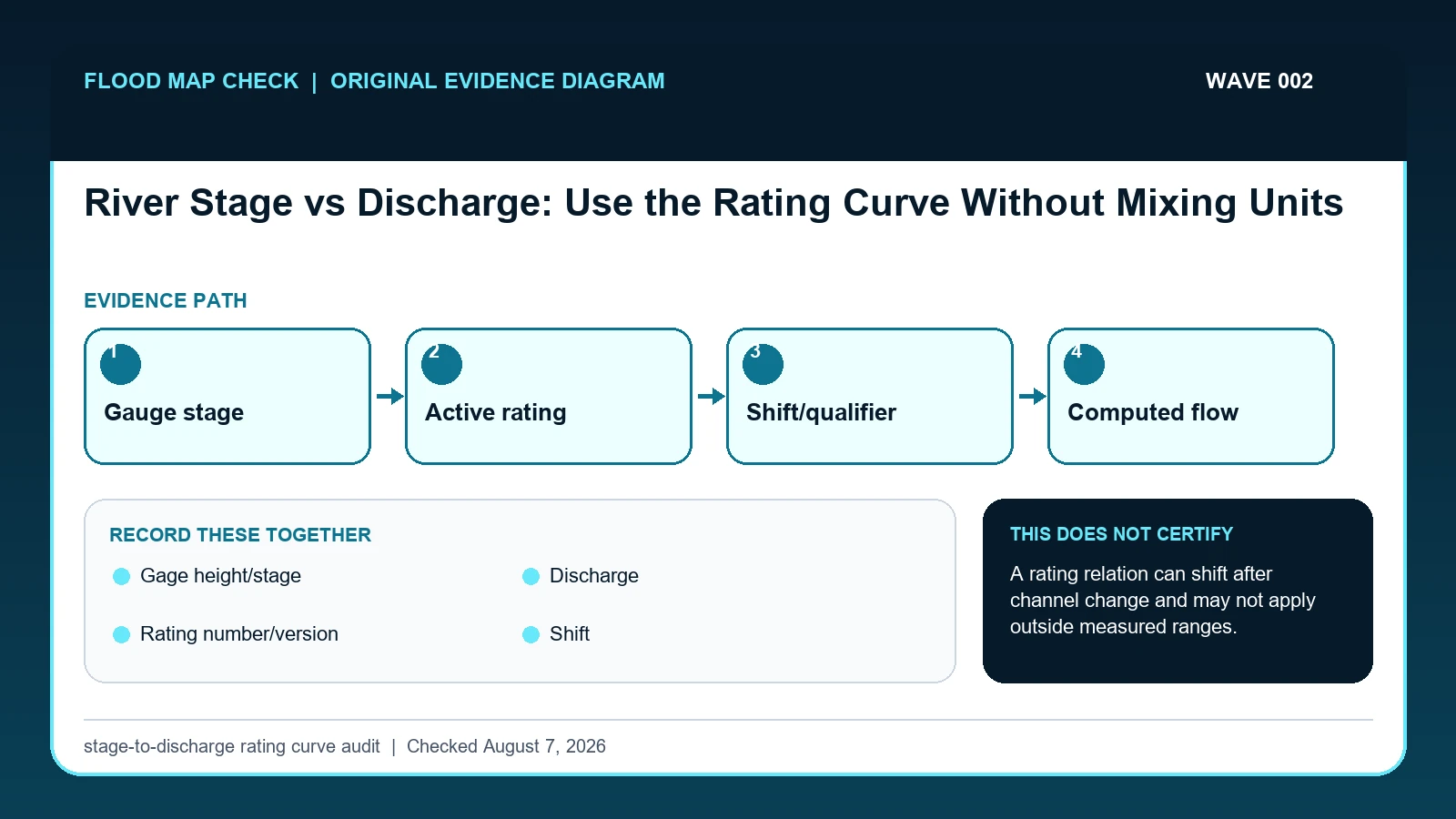
River stage is water-surface height relative to a gauge reference; discharge is the volume of water passing a section per unit time. A station's rating curve relates the two, but that relationship can shift with channel change, vegetation, ice, backwater, or measurement updates, so a stage-to-flow conversion must retain the station, time, rating, and qualifiers.
Last checked: August 7, 2026.
Stage and discharge answer different questions. Stage tells how high the water is at the gauge reference. Discharge, commonly expressed in cubic feet per second, estimates how much water passes the site. USGS develops a rating from field measurements and hydraulic interpretation, then uses it to compute discharge from recorded stage. Because the channel is not a permanent pipe, the same stage can correspond to a different discharge after scour, deposition, debris, or a temporary shift correction.
A rating curve is a measured relation, not a universal formula
Stage is a water-surface height above a gauge reference; discharge is an estimated volume of water passing a cross section per unit time. A rating curve relates the two at a station, but it is not a permanent conversion formula for every flow. USGS develops and adjusts ratings from measurements, hydraulic controls, shifts, and station history. Copying one stage-discharge pair to another date or another gauge ignores the physical relation that produced the value.
A simple table can reveal the issue. If a published rating associates 8.0 feet with 5,000 cubic feet per second and 9.0 feet with 7,500, linear interpolation would suggest 6,250 at 8.5 feet. That is only an illustrative calculation; an actual rating may curve, include a shift, or be exceeded during extreme flow. The official computed discharge and rating information should remain the evidence, with the stage and time retained so the estimate can be reconstructed.
Backwater, ice, vegetation, channel change, and unsteady flow can break an assumed one-to-one relation. A rising river and a falling river may show different discharge at the same stage, a behavior often called hysteresis. When the station marks discharge provisional or publishes a qualifier, do not smooth the difference away. Preserve the qualifier and ask whether the intended decision needs observed stage, computed flow, a forecast category, or a surveyed elevation; those are separate products.
USGS station records behind stage and discharge
USGS shift-adjusted rating explanation supplies how station-specific stage-discharge ratings are developed and why temporary hydraulic changes require rating shifts; this guide cites it for Gage height/stage / Discharge / Rating number/version / Shift. USGS Water Data for the Nation supplies monitoring-location metadata, instantaneous values, daily values, peaks, and qualification codes; this guide cites it for Gage height/stage / Discharge / Qualifier. USGS provisional-data statement supplies why near-real-time records are subject to review, correction, and approval; this guide cites it for Qualifier.
The river stage vs discharge crosswalk keeps these assignments explicit: USGS shift-adjusted rating explanation → Gage height/stage / Discharge / Rating number/version / Shift; USGS Water Data for the Nation → Gage height/stage / Discharge / Qualifier; USGS provisional-data statement → Qualifier. If Gage height/stage or another named field is absent from its cited record, leave that fact unresolved and obtain it from the responsible official source instead of expanding a different citation beyond scope.
| Official record | What it actually supplies | Field used here |
|---|---|---|
| USGS shift-adjusted rating explanation | how station-specific stage-discharge ratings are developed and why temporary hydraulic changes require rating shifts | Gage height/stage / Discharge / Rating number/version / Shift |
| USGS Water Data for the Nation | monitoring-location metadata, instantaneous values, daily values, peaks, and qualification codes | Gage height/stage / Discharge / Qualifier |
| USGS provisional-data statement | why near-real-time records are subject to review, correction, and approval | Qualifier |
For this check, the cited evidence is limited to Gage height/stage, Rating number/version, and Qualifier plus the other fields named in the crosswalk. Record a changed or missing Rating number/version value with the retrieval date before taking the action to link stage and flow only through the station's applicable rating, then request clarification from its publishing agency.
How Gage height/stage connects to Qualifier
| Field | Meaning in this check | Error it exposes | Response |
|---|---|---|---|
| Gage height/stage | Height above the station's gauge datum | Not elevation above sea level unless converted | Keep parameter code, unit, time, and datum |
| Discharge | Flow volume per unit time | Often computed from a rating | Keep parameter code, unit, and approval status |
| Rating number/version | Relationship used for conversion | A later rating may differ | Retain the applicable period and revision |
| Shift | Temporary correction to the base rating | Signals changed hydraulic control | Preserve shift notes and measurements |
| Qualifier | Provisional, estimated, ice, equipment, or other context | May limit comparison | Carry qualifiers into charts and summaries |
Read the table in two passes. First confirm Gage height/stage, Discharge, and Rating number/version. They answer “Height above the station's gauge datum”, “Flow volume per unit time”, and “Relationship used for conversion”. Any disagreement among Gage height/stage, Discharge, and Rating number/version should remain visible rather than being blended into one result.
Next test for two different problems: “Not elevation above sea level unless converted” and “A later rating may differ”. They require different corrections. For the first, follow “Keep parameter code, unit, time, and datum”; for the second, follow “Retain the applicable period and revision”.
Shift and Qualifier show when to stop. The warning conditions are “Signals changed hydraulic control” and “May limit comparison”. The limits on Shift and Qualifier keep the evidence useful without making the broader decision reserved for the named authority or professional.
Reconstruct the value from station, time, rating, and qualifier
Verify two checkpoints before interpreting Qualifier: “Open station metadata to find gauge datum and the period represented by the data”, followed by “Retain approval status and every qualifier rather than copying only the numeric column”. If the first checkpoint fails, stop before applying the second to a possibly wrong Gage height/stage subject or record.
- Confirm station number, station name, drainage setting, parameter code, and unit.
- Identify whether the downloaded value is measured stage, computed discharge, or a forecast.
- Open station metadata to find gauge datum and the period represented by the data.
- Retain approval status and every qualifier rather than copying only the numeric column.
- Check measurement and rating information when converting or explaining stage versus flow.
- Flag ice, backwater, rapid channel change, equipment issues, and gaps as interpretation limits.
- For a decision, pair the hydrologic record with current NWS messages and local flood-impact information.
The file is ready for later review only after this final action: “For a decision, pair the hydrologic record with current NWS messages and local flood-impact information”. Keep Gage height/stage, Rating number/version, and Qualifier in that record so a future update shows exactly what changed.
Why 8.5 feet does not authorize a universal flow conversion
Imagine two readings of 12.0 feet months apart. If the channel bed scoured during a flood, the later 12.0-foot stage may carry more flow; if debris caused backwater, it may carry less. The numbers are not interchangeable until the approved rating and any shift used for each period are known. For inundation decisions, also verify whether the local forecast category is expressed as stage or flow.
In this example, Gage height/stage identifies the relevant record, while Rating number/version is the fact most likely to change the interpretation. Conclude “Conversion may be routine” only when the evidence shows “Measurements fit the active rating”.
For river stage vs discharge, if the facts instead fit “Different stations”, the result changes to “Numeric comparisons can mislead”. Respond by following “Compare standardized hydrologic metrics, not raw stage”. Do not substitute the more favorable conclusion from the earlier example.
Active rating, shifted control, extreme flow, and unavailable discharge
| Observed state | Evidence test | Limited conclusion | Next response |
|---|---|---|---|
| Stable control | Measurements fit the active rating | Conversion may be routine | Still retain rating and approval metadata |
| Shift applied | Temporary departure from base rating | Hydraulic control changed | Use the shifted result for its stated period |
| Backwater or ice | Stage no longer maps cleanly to one flow | Conversion uncertainty increases | Prefer reviewed values and explanatory notes |
| Different stations | Separate datums, ratings, and channel sections | Numeric comparisons can mislead | Compare standardized hydrologic metrics, not raw stage |
Use “Measurements fit the active rating” to recognize “Stable control”. If the facts instead meet “Temporary departure from base rating”, report “Hydraulic control changed” and follow “Use the shifted result for its stated period”.
If the observation matches “Stage no longer maps cleanly to one flow”, stop at “Conversion uncertainty increases”. If it matches “Separate datums, ratings, and channel sections”, stop at “Numeric comparisons can mislead”. The corresponding actions are “Prefer reviewed values and explanatory notes” and “Compare standardized hydrologic metrics, not raw stage”.
Backwater, ice, shifts, and hysteresis
- Avoid calling stage an elevation. Recheck Gage height/stage. The mapped warning is “Not elevation above sea level unless converted”; the corresponding response is “Keep parameter code, unit, time, and datum”.
- Avoid converting with another station's rating. Recheck Rating number/version. The mapped warning is “A later rating may differ”; the corresponding response is “Retain the applicable period and revision”.
- Avoid discarding shift or qualifier fields. Recheck Shift / Qualifier. The mapped warning is “Signals changed hydraulic control; May limit comparison”; the corresponding response is “Preserve shift notes and measurements; Carry qualifiers into charts and summaries”.
- Avoid treating provisional computed flow as final. Recheck Qualifier. The mapped warning is “May limit comparison”; the corresponding response is “Carry qualifiers into charts and summaries”.
“calling stage an elevation” can trigger Not elevation above sea level unless converted; correct the mapped Gage height/stage field or fields by following “Keep parameter code, unit, time, and datum”. “converting with another station's rating” affects Rating number/version, so use “Retain the applicable period and revision” before relying on the result.
The remedy for “discarding shift or qualifier fields” is tied to Shift / Qualifier: “Preserve shift notes and measurements; Carry qualifiers into charts and summaries”. The separate mistake “treating provisional computed flow as final” is exposed by “May limit comparison”; answer it with “Carry qualifiers into charts and summaries”.
What this stage-to-discharge rating curve audit cannot decide
Scope: United States observed and forecast river conditions. Limitation: A rating relation can shift after channel change and may not apply outside measured ranges.
This comparison can expose a conflict between Gage height/stage and Rating number/version, but it cannot resolve “Different stations”. In that condition, the defensible next step remains “Compare standardized hydrologic metrics, not raw stage”.
Separate the rating check from datum and flood-category work
- Carry the verified Gage height/stage to River Flood Risk Check if that linked topic is the reader’s next question.
- Keep Rating number/version attached to its source when moving to USGS Streamstats Flood Frequency Report.
- Treat USGS Flood Event Viewer High Water Marks as a separate review triggered by Qualifier while working to link stage and flow only through the station's applicable rating, not as confirmation of the result here.
Use this guide to link stage and flow only through the station's applicable rating. The linked guides address separate questions raised by Gage height/stage, Rating number/version, or Qualifier.
Before citing a stage-discharge pair
Does Gage height/stage settle the question by itself?
No. Gage height/stage answers “Height above the station's gauge datum”, but it can fail when “Not elevation above sea level unless converted”. Pair it with Discharge, Rating number/version, and the checked date.
What if the evidence shows Different stations?
Confirm the stated evidence test: “Separate datums, ratings, and channel sections”. The limited conclusion is “Numeric comparisons can mislead”. The documented response is “Compare standardized hydrologic metrics, not raw stage”; a more favorable branch should not be substituted.
When should Qualifier be checked again?
Recheck the stage-discharge relation when USGS publishes a new rating, applies a shift, changes an approval flag, or documents backwater, ice, vegetation, or channel change. The same stage can support a different computed flow after the station control changes.
River Stage vs Discharge: Use the Rating Curve Without Mixing Units is independent public-record guidance for the limited action to link stage and flow only through the station's applicable rating. The cited government records retain authority over Gage height/stage and Qualifier. Last checked: August 7, 2026.