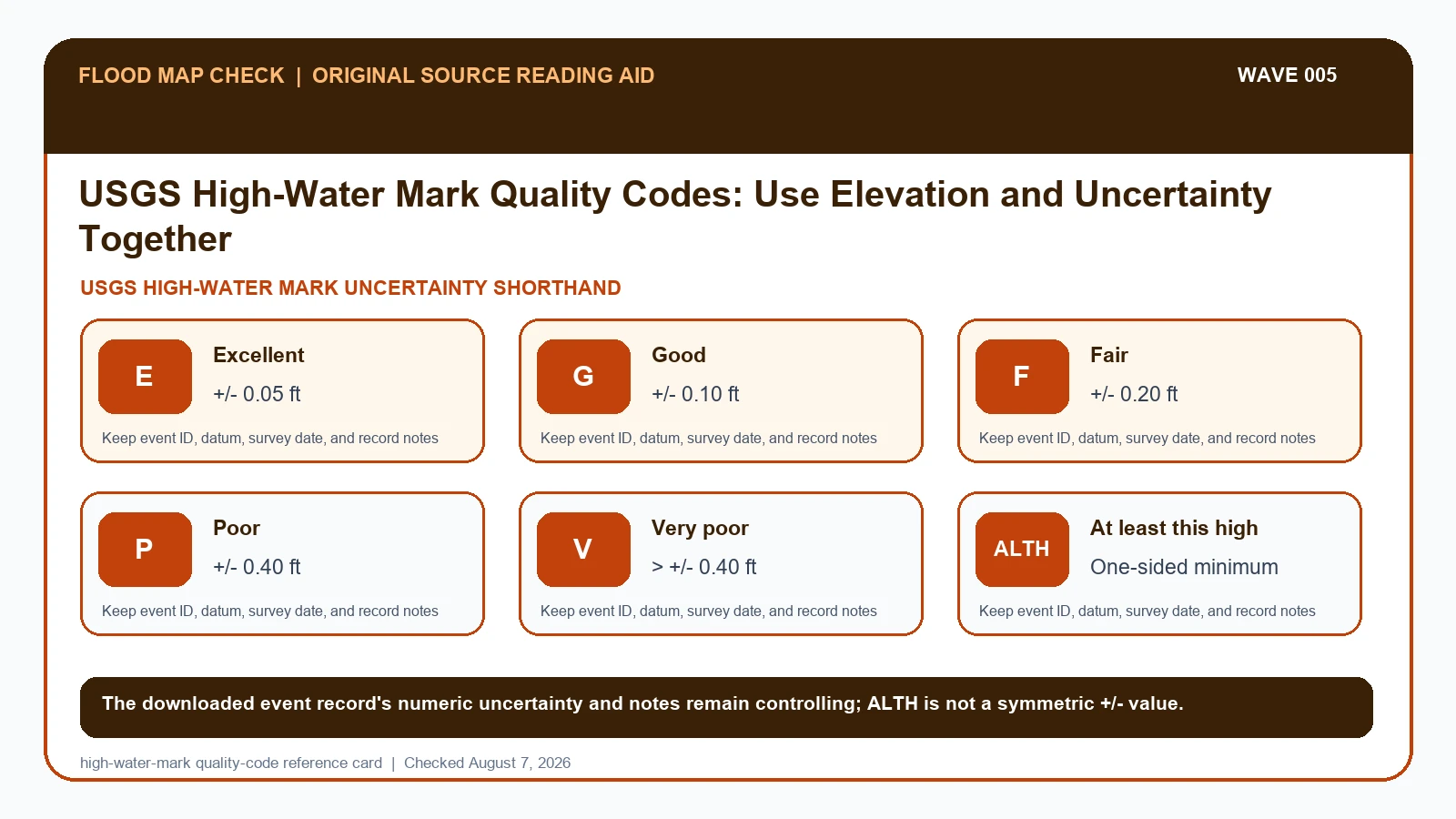
A USGS high-water mark must be read with its event, mark ID, evidence type, quality shorthand, numeric uncertainty, surveyed elevation, vertical datum, and survey date. The field manual uses E, G, F, P, V, and ALTH as shorthand for excellent, good, fair, poor, very poor, and at-least-this-high evidence; retain the event record's numeric uncertainty because the letter alone is not a universal precision guarantee.
Last checked: August 7, 2026.
USGS crews identify perishable evidence such as seed, debris, mud, stain, and wash lines, then flag, photograph, describe, and survey selected marks. The field manual pairs E with about plus or minus 0.05 foot, G with 0.10 foot, F with 0.20 foot, P with 0.40 foot, V with more than 0.40 foot, and ALTH with a one-sided minimum-height meaning. Event and project records can carry their own field rules, so the downloaded uncertainty and notes remain controlling. Marks from the same flood can legitimately differ because they occupy different hydraulic settings.
E, G, F, P, V, and ALTH carry different uncertainty meanings
The USGS field manual's shorthand makes the quality promise concrete: E is excellent at about plus or minus 0.05 foot, G is good at 0.10 foot, F is fair at 0.20 foot, P is poor at 0.40 foot, V is very poor at more than 0.40 foot, and ALTH means the mark establishes at least that height while the peak may have been higher. The event download's numeric uncertainty and notes should accompany the letter code.
A comparison should be designed before averaging. Group marks by event and vertical datum, inspect evidence type and photographs, define an inclusion rule, and retain uncertainty. If two sheltered marks are 8.20 plus or minus 0.05 feet and 8.34 plus or minus 0.10 feet in the same datum, their uncertainty intervals overlap only narrowly or not at all depending on the adopted treatment; local slope or hydraulics may be real, so an automatic mean can hide useful structure.
Wave runup, debris lodged above stillwater, sloping stains, disturbed seed lines, and delayed field visits can change what a mark represents. ALTH is one-sided evidence and should not be treated like a symmetric plus-or-minus value. Quality thresholds in a particular event file or project form may differ from a shorthand seen elsewhere, which is why the downloaded dictionary, record notes, survey date, approval state, and numeric uncertainty remain part of the citation.
The STN dictionary and field manual define the mark record
USGS Short-Term Network data portal and dictionaries supplies the public High-water Mark data dictionary and event-download fields used for mark identity, quality, elevation, datum, uncertainty, and approval state; this guide cites it for Event/mark ID / Mark type/description / Quality rating / Elevation/datum / Uncertainty / Survey/flag date. USGS High-Water Mark Field Manual supplies the E, G, F, P, V, and ALTH uncertainty shorthand and the field reasoning used to assign an uncertainty rather than treating quality as decoration; this guide cites it for Mark type/description / Quality rating / Uncertainty. USGS Flood Event Viewer supplies event-based high-water marks, sensors, storm tide, wave height, and downloads; this guide cites it for Event/mark ID / Elevation/datum / Survey/flag date.
The USGS high water mark quality crosswalk keeps these assignments explicit: USGS Short-Term Network data portal and dictionaries → Event/mark ID / Mark type/description / Quality rating / Elevation/datum / Uncertainty / Survey/flag date; USGS High-Water Mark Field Manual → Mark type/description / Quality rating / Uncertainty; USGS Flood Event Viewer → Event/mark ID / Elevation/datum / Survey/flag date. If Event/mark ID or another named field is absent from its cited record, leave that fact unresolved and obtain it from the responsible official source instead of expanding a different citation beyond scope.
| Official record | What it actually supplies | Field used here |
|---|---|---|
| USGS Short-Term Network data portal and dictionaries | the public High-water Mark data dictionary and event-download fields used for mark identity, quality, elevation, datum, uncertainty, and approval state | Event/mark ID / Mark type/description / Quality rating / Elevation/datum / Uncertainty / Survey/flag date |
| USGS High-Water Mark Field Manual | the E, G, F, P, V, and ALTH uncertainty shorthand and the field reasoning used to assign an uncertainty rather than treating quality as decoration | Mark type/description / Quality rating / Uncertainty |
| USGS Flood Event Viewer | event-based high-water marks, sensors, storm tide, wave height, and downloads | Event/mark ID / Elevation/datum / Survey/flag date |
Use the cited records only to filter and disclose measurement quality before comparing marks. If an official page no longer publishes Event/mark ID, save its URL and checked date, mark that fact unavailable, and ask the agency or data owner rather than borrowing it from a secondary summary.
The Flood Event Viewer supplies event, mark, elevation, and date context; the field manual and STN dictionary control quality, uncertainty, and record-field interpretation. The Decision scope row is an editorial limitation derived from those records, not a field supplied by the Viewer.
How Event/mark ID connects to Decision scope
| Field | Meaning in this check | Error it exposes | Response |
|---|---|---|---|
| Event/mark ID | Identifies flood and observation | IDs must remain paired | Keep in every row |
| Mark type/description | Physical evidence used | Evidence responds differently to flow/waves | Read notes/photos |
| Quality rating | Clarity/reliability assessment | Not decorative | Apply disclosed filter |
| Elevation/datum | Surveyed vertical result | Incompatible datums cannot be averaged | Normalize with documented method |
| Uncertainty | Measurement/evidence limit | Point is not exact | Carry into comparison |
| Survey/flag date | Timing after event | Marks degrade | Use as quality context |
| Decision scope | States whether the mark is being used for event reconstruction, engineering comparison, or another limited task | A single event mark is not a BFE, parcel determination, or future-flood prediction | Keep the conclusion inside the stated analytical purpose |
Begin with Event/mark ID, which answers “Identifies flood and observation”. Check Mark type/description separately because it answers “Physical evidence used”. If the record instead shows “Evidence responds differently to flow/waves”, use the stated correction: “Read notes/photos”.
Quality rating can change the interpretation because it answers “Clarity/reliability assessment”. Its main warning is “Not decorative”. Read that warning beside Survey/flag date so place, period, unit, and reference remain attached to the same evidence.
Finish the comparison with Decision scope. It answers “States whether the mark is being used for event reconstruction, engineering comparison, or another limited task”, while “A single event mark is not a BFE, parcel determination, or future-flood prediction” marks the point where a broader conclusion would be unsafe. When that condition appears, follow “Keep the conclusion inside the stated analytical purpose” and leave the larger decision open.
Group the event and datum before comparing elevations
Treat “Inspect available photographs and notes to understand the physical evidence” as a prerequisite for “Write the quality inclusion rule before calculating summaries”. Together they determine whether Quality rating belongs to the same subject, period, and official product as Event/mark ID.
- Choose the exact Flood Event Viewer event and download high-water-mark records with metadata.
- Retain event ID, mark ID, coordinates, type, description, quality, dates, elevation, datum, and uncertainty.
- Inspect available photographs and notes to understand the physical evidence.
- Write the quality inclusion rule before calculating summaries.
- Separate coastal wave/runup settings, riverine marks, and other hydraulic contexts.
- Transform datums only with documented methods and propagate uncertainty.
- Cite the event-specific record and avoid using one mark as a regulatory or parcel flood elevation.
Do not close the file at the first plausible result. Carry out “Cite the event-specific record and avoid using one mark as a regulatory or parcel flood elevation”, then preserve the version of Decision scope that was current on the checked date.
Two nearby marks whose uncertainty should not be averaged away
Do not average every point downloaded near an address. First group by event and vertical datum, remove records that do not meet the stated quality rule, inspect type and notes, then map residual differences. A high mark on wave-exposed debris and a sheltered stillwater stain may answer different physical questions.
In this example, Event/mark ID identifies the relevant record, while Quality rating is the fact most likely to change the interpretation. Conclude “Strong event elevation evidence” only when the evidence shows “Clear evidence and survey”.
For USGS high water mark quality, if the facts instead fit “Datum mismatch”, the result changes to “Direct comparison invalid”. Respond by following “Transform or separate”. Do not substitute the more favorable conclusion from the earlier example.
Strong sheltered mark, weak evidence, wave effect, and datum conflict
| Observed state | Evidence test | Limited conclusion | Next response |
|---|---|---|---|
| High-quality sheltered mark | Clear evidence and survey | Strong event elevation evidence | Use with datum/uncertainty |
| Poor/uncertain mark | Ambiguous or degraded evidence | Weak comparison | Exclude or flag by rule |
| Wave-affected coastal mark | Setup/runup/local effects possible | Not simple stillwater | Use type-specific interpretation |
| Datum mismatch | Marks reference different vertical systems | Direct comparison invalid | Transform or separate |
When the evidence shows “Clear evidence and survey”, the limited conclusion is “Strong event elevation evidence” and the next action is “Use with datum/uncertainty”. By contrast, “Poor/uncertain mark” requires “Exclude or flag by rule” because its evidence test is “Ambiguous or degraded evidence”.
For “Wave-affected coastal mark”, use “Use type-specific interpretation”. For “Datum mismatch”, use “Transform or separate”. Across Wave-affected coastal mark and Datum mismatch, neither branch permits an unsupported favorable conclusion when the stated evidence is absent.
Wave effects, one-sided marks, and project-specific rules
- Avoid averaging all marks. Recheck Quality rating / Elevation/datum / Uncertainty. The mapped warning is “Not decorative; Incompatible datums cannot be averaged; Point is not exact”; the corresponding response is “Apply disclosed filter; Normalize with documented method; Carry into comparison”.
- Avoid dropping quality rating. Recheck Quality rating. The mapped warning is “Not decorative”; the corresponding response is “Apply disclosed filter”.
- Avoid mixing datums. Recheck Elevation/datum. The mapped warning is “Incompatible datums cannot be averaged”; the corresponding response is “Normalize with documented method”.
- Avoid calling one event mark a future BFE. Recheck Decision scope. The mapped warning is “A single event mark is not a BFE, parcel determination, or future-flood prediction”; the corresponding response is “Keep the conclusion inside the stated analytical purpose”.
Two field-specific corrections are required. For “averaging all marks”, follow “Apply disclosed filter; Normalize with documented method; Carry into comparison”. For “dropping quality rating”, follow “Apply disclosed filter”. Keeping Quality rating / Elevation/datum / Uncertainty separate from Quality rating prevents one repaired field from hiding the other error.
“mixing datums” can trigger Incompatible datums cannot be averaged; correct the mapped Elevation/datum field or fields by following “Normalize with documented method”. “calling one event mark a future BFE” affects Decision scope, so use “Keep the conclusion inside the stated analytical purpose” before relying on the result.
What this high-water-mark quality-code reference card cannot decide
Scope: United States public historical flood datasets. Limitation: A high-water mark is event-specific and may not represent stillwater at a property.
The high-water-mark quality-code reference card keeps Event/mark ID, Quality rating, and Decision scope in one comparison; it does not filter and disclose measurement quality before comparing marks on the reader’s behalf. If the facts match “Datum mismatch”, follow “Transform or separate” with the responsible agency or professional.
Connect the event record to separate historical-flood checks
- After confirming Event/mark ID, continue to OpenFEMA NFIP Claims Data By County only for the separate question named there.
- Use OpenFEMA Disaster Declarations Flood Filter when Quality rating raises an issue outside this article’s evidence test.
- Open USGS Flood Event Viewer High Water Marks if Decision scope requires a broader official-record review.
Use this guide to filter and disclose measurement quality before comparing marks. The linked guides address separate questions raised by Event/mark ID, Quality rating, or Decision scope.
Before filtering USGS high-water marks
Does Event/mark ID settle the question by itself?
No. Event/mark ID answers “Identifies flood and observation”, but it can fail when “IDs must remain paired”. Pair it with Mark type/description, Quality rating, and the checked date.
What if the evidence shows Datum mismatch?
Confirm the stated evidence test: “Marks reference different vertical systems”. The limited conclusion is “Direct comparison invalid”. The documented response is “Transform or separate”; a more favorable branch should not be substituted.
When should Decision scope be checked again?
Update the comparison when an event record gains approval, a quality code changes, a surveyed elevation or datum is corrected, or USGS adds notes and numeric uncertainty. Keep ALTH as one-sided evidence even if a later download supplies a more precise-looking number.
USGS High-Water Mark Quality Codes: Use Elevation and Uncertainty Together is independent public-record guidance for the limited action to filter and disclose measurement quality before comparing marks. The cited government records retain authority over Event/mark ID and Decision scope. Last checked: August 7, 2026.