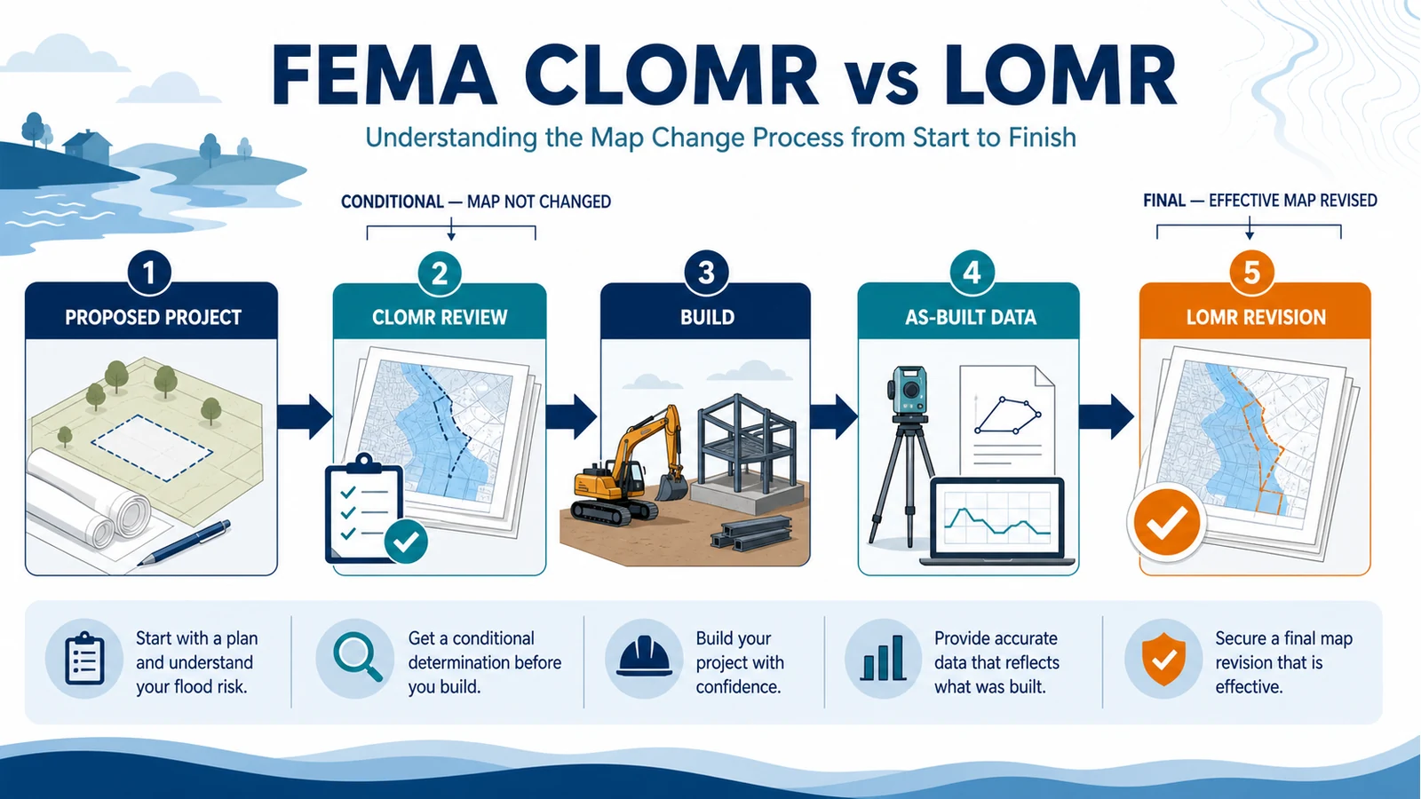
Use a CLOMR before construction when FEMA must review whether a proposed project or proposed hydrology change would meet minimum National Flood Insurance Program standards if built as designed. Use a LOMR after the change exists when completed work, corrected mapping or current-condition data support an official revision to the effective Flood Insurance Rate Map or Flood Insurance Study. A CLOMR is conditional: it neither revises the effective map nor replaces the local permit. A LOMR can revise effective flood elevations, floodplain or floodway boundaries, or related study information for the stated area.
This is a project-level MT-2 decision for developers, engineers, property owners and community officials. Begin with the effective FIRM and FIS, the project limits and the local floodplain administrator. Do not choose a request from the acronym alone; the controlling question is whether FEMA is being asked to review proposed conditions or revise the map using existing conditions.
CLOMR and LOMR solve different stages of the same project
FEMA describes a CLOMR as its comment on a proposed project or proposed hydrology change. By contrast, FEMA describes a LOMR as a letter that officially revises current NFIP mapping. The distinction is also built into 44 CFR 65.6: a final revision cannot be based on the effects of a proposed project or future conditions.
| Question | CLOMR | LOMR |
|---|---|---|
| When is it used? | Before the proposed encroachment or map-changing work is permitted and built | After physical changes exist, or when current data support a final revision |
| What does FEMA review? | Proposed hydrology, hydraulics, structures, terrain and post-project mapping | Certified existing or as-built conditions, corrected or improved data, and revised mapping |
| Does it change the effective FIRM or FIS? | No. It is a conditional comment on the proposal | Yes, if FEMA issues the revision and it reaches the effective status stated in the letter |
| Does it authorize construction? | No. The community still decides the local permit | No. It records a federal map action, not local construction approval |
| Which form family? | MT-2 for project-level conditional revisions | MT-2 for project-level final revisions |
| Typical evidence state | Design plans and proposed-condition models | As-built plans, survey or terrain data, and current-condition models |
Start with the effective FIRM, FIS and community official
Before an engineer builds a model package, identify the effective flood study that the request would change. Record the community number, FIRM panel number and suffix, effective date, flooding source, flood zone, regulatory floodway status, Base Flood Elevations, study reach and vertical datum. The FEMA FIRM panel guide explains how to keep the panel, index and effective date attached to the correct place.
Then contact the local floodplain administrator before treating the federal minimum as the whole rule. The community administers its floodplain ordinance and development permits, may use higher standards, and must participate in the map-revision process. Ask which effective model and datum it uses, whether preliminary or locally adopted data also affect design, which communities are impacted, and what approvals must precede submission. Save the official’s written response with the case file.
When a CLOMR belongs before the project
A CLOMR is not required for every project in a mapped floodplain. It becomes the federal conditional-revision path when the proposed encroachment would exceed the NFIP limits that the community may otherwise permit, or when a stricter local rule requires one. Under 44 CFR 60.3, development in certain AE areas without an adopted floodway must keep the cumulative base-flood water-surface increase to no more than one foot. Within an adopted regulatory floodway, an encroachment must demonstrate no increase in base-flood levels unless the conditional revision route is completed first.
44 CFR 65.12 places the application duty on the community when it proposes to permit an encroachment that exceeds those limits. The rule calls for conditional approval before the encroachment is permitted, along with alternatives analysis, notice to impacted owners, concurrence from other affected communities where applicable, and the technical requests for BFE and floodway revision. The project team should therefore settle the local permitting and community-coordination path before assuming a private FEMA filing can stand alone.
Build the proposed-condition record before submitting a CLOMR
A workable CLOMR package lets FEMA reproduce the comparison between effective, existing and proposed conditions. The current FEMA MT-2 Requests guidance explains that the local permit remains separate and that affected communities need an opportunity to review the package. It also ties the conditional request to applicable permits and community concurrence.
- Effective model: the duplicate-effective hydrologic and hydraulic model used to establish a defensible baseline.
- Corrected-existing model: justified corrections needed to represent the current pre-project condition without silently rewriting the effective baseline.
- Proposed-condition model: every project change applied to the accepted baseline, with results that tie back to the unaffected study reach.
- Work maps and tables: existing and proposed floodplain and floodway delineations, cross sections, profiles and BFE changes shown at a usable scale.
- Design evidence: plans, calculations, structures data, terrain, survey control, datum conversions and professional certifications appropriate to the request.
- Community and notice record: Form 1 signatures or documented coordination, affected-owner notice when required, permits and responses from impacted jurisdictions.
- Environmental record: the Endangered Species Act compliance documentation FEMA requires before reviewing a conditional LOMC.
FEMA’s paper application forms page separates the MT-2 package from the parcel-oriented MT-EZ and MT-1 packages and explains the ESA documentation rule. Use the live page on the submission date because forms, fees, payment instructions and routing can change.
A CLOMR is not permission to build
An issued CLOMR says FEMA finds that the proposal, if built as submitted, would meet minimum NFIP mapping standards. It does not adopt the design, issue a floodplain development permit, satisfy building or environmental approvals, guarantee that the community will approve the work, or alter the current effective map. The community may still deny the permit or apply stricter standards.
Move to a LOMR only after the conditions exist
A CLOMR does not automatically turn into a LOMR. After construction, the team must document what was actually built and submit the final MT-2 request supported by existing-condition evidence. Section 65.6 requires current-condition data, logical transitions to unrevised flood information, datum identification, appropriate hydrologic and hydraulic analyses, revised delineations and professional certification. For physical changes, the rule specifically calls for as-built plans or certifications and the analyses appropriate to hydrologic, hydraulic or topographic changes.
- Compare the approved design, issued CLOMR and constructed work; list every departure.
- Collect certified as-built plans, survey or terrain data and final structure geometry.
- Update the current-condition model and preserve the effective and corrected-existing runs used for comparison.
- Recalculate profiles, BFEs, floodplain and floodway boundaries and transition points for the affected reach.
- Obtain the community assurances, permits and certifications applicable to the completed project.
- Submit the final MT-2 package and retain FEMA’s case number, requests for additional data and final determination letter.
Until the final letter reaches the effective status stated by FEMA, keep the original effective map and the conditional letter labeled separately. A planned or constructed project is not itself proof that the FIRM has changed. If the underlying question is whether a preliminary communitywide map has replaced the current map, use the preliminary versus effective FEMA map guide instead of treating the project file as the map status.
Use only the MT-2 forms that match the analysis
The current FEMA MT-2 instructions are the checklist for both conditional and final project-level revisions. Form 1 is the Overview and Concurrence Form. The remaining technical forms are selected according to the flooding source and work; submitting every form does not cure a missing analysis, while omitting an applicable form creates a completeness problem.
| MT-2 part | Use it when the request includes |
|---|---|
| Form 1 — Overview and Concurrence | Request identity, affected panels and communities, certifications and community coordination |
| Form 2 — Riverine Hydrology and Hydraulics | New or revised discharges, water-surface elevations, riverine floodplain or floodway analysis |
| Form 3 — Riverine Structures | Channel work, bridges, culverts, dams, levees or floodwalls |
| Form 4 — Coastal Analysis | New or revised coastal flood elevations or coastal analyses |
| Form 5 — Coastal Structures | A new or revised coastal structure |
| Form 6 — Alluvial Fan Flooding | Flood-control measures or mapping changes on an alluvial fan |
Confirm the current online or paper route on FEMA’s LOMR and CLOMR page. Online submissions and paper packages can have different fee handling under 44 CFR Part 72, and some locations are routed through a Cooperating Technical Partner or state reviewer. Do not copy an old fee, mailing address or form edition from a prior case. Save the live instructions used on the day of filing.
Errors that slow or misdirect the request
- Using a LOMR for a future design. FEMA cannot issue a final revision based on proposed conditions; use the conditional route when the project is still proposed.
- Treating the CLOMR as a permit. Keep FEMA’s conditional review and the community’s development approval as separate records.
- Starting from the wrong model or datum. Identify the effective study, preserve the baseline and document every correction or conversion.
- Leaving the community until the end. Community concurrence, assurances, permits and affected-jurisdiction coordination are part of the process, not a courtesy after filing.
- Submitting only a proposed model. FEMA needs a reproducible chain from effective to existing to proposed conditions, and later to as-built conditions for the LOMR.
- Ignoring transitions and downstream effects. Revised elevations and boundaries must connect logically to the unrevised study beyond the project reach.
- Freezing old administrative details. Recheck current forms, fees, ESA documentation, state or CTP routing and submission instructions at filing.
Know when another FEMA process is the right one
LOMR and CLOMR are easy to confuse with other letters because FEMA groups them under Letters of Map Change. Keep each searcher’s actual problem attached to the correct process:
- LOMA: a parcel or structure on natural ground may have been inadvertently included in the Special Flood Hazard Area. This is not a project-level MT-2 revision.
- LOMR-F: a parcel or structure has been elevated by fill and the request concerns its mapped SFHA status. Use the LOMA and LOMR-F guide for that parcel-level route.
- LODR: a borrower or lender disputes a lender-issued flood-hazard determination using the effective map and supporting data. A Letter of Determination Review does not revise the FIRM.
- Preliminary-map appeal or comment: a communitywide proposed map is in its formal review process. That is different from asking FEMA to review one proposed development through a CLOMR.
What the FEMA letter does not decide
Flood Map Check is an independent routing and interpretation guide, not FEMA, a community official or an engineering reviewer. A CLOMR or LOMR does not establish a surveyed property boundary, legal title, project ownership, insurance premium, lender requirement, building-code compliance, environmental approval or current flood safety. It also does not replace the professional certifications and local decisions that the project requires.
Keep the determination letter with its case number, exhibits, effective-date language, revised panels or FIS material and community file. For a permit or property decision, ask the responsible local authority which documents it recognizes and whether a later FIRM revision, revalidation or project change affects the result.
Questions project teams still ask
Does every floodplain project need a CLOMR?
No. The federal conditional-revision trigger depends on the project’s modeled effect and the applicable floodway condition, while a community may enforce a stricter rule. Ask the local floodplain administrator and the project engineer to document the trigger before design approval.
Can FEMA issue a LOMR before construction is complete?
A final LOMR must be based on existing conditions, not the effects of proposed work. A proposed project belongs in the CLOMR process; after completion, certified as-built and current-condition evidence supports the LOMR request.
Does an issued CLOMR guarantee the later LOMR?
No. The completed project and final analysis must match the condition FEMA reviewed and satisfy the final revision requirements. Design changes, construction deviations, missing certifications or different model results can require more work before a LOMR is issued.
Who should sign or certify an MT-2 package?
Use the current MT-2 instructions for the exact signature pages. The requester, affected community officials and qualified professionals have different roles; technical analyses and data must be certified by a registered professional engineer or licensed land surveyor as appropriate under 44 CFR 65.6.
Sources checked July 28, 2026: FEMA’s LOMR/CLOMR overview, current MT-2 forms and instructions, MT-2 Requests guidance, the FEMA paper-form route, and current 44 CFR 60.3, 65.6, 65.12 and Part 72. Reopen the official sources before filing because forms, fees, routing and local requirements can change.
Use the next official workflow
- Is Your LOMA Still Valid After a New FEMA Map? Check the Revalidation Letter — A later map revision can change how an older LOMC is carried forward; verify the current revalidation record.